
Page 44 - 2020 AMA Summer
P. 44
MISCARTICLE
IS IT JUST ME...
OR IS IT COIRE
AN LOCHAIN?
Duncan Francis
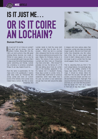
Is it just me? Or is it Coire an Lochain? Now don’t get me wrong; I love the Northern Corries. Along with Cha No,
Hell’s Lum and Lurcher’s, they offer great climbing [Some Summer, but mostly in Winter] on every aspect, not so very far from a car park [although it may seem like it in deep snow]. But while Sneachda always seems welcoming and friendly, Lochain has a tendency to somehow complicate things. Or, as I say, maybe it’s just me...
Even the name is questionable. On the maps and in the guidebooks it seems quite clear, Coire an t’Sneachda [the snowy corrie] and Coire an Lochain [corrie of the lochan]. And Lochain does indeed have a lochan. But then so does
Sneachda. And
Lochain tends to hold the snow both earlier and later than its twin. So it is snowier... Which has led to a surmise often whispered that the two corries had their names switched at some point in the past. Maybe the Ordnance Survey is to blame. The names of Cairn Lochan [not Lochain] and Stob Coire an t’Sneachda may have come later... Who knows? It’s probably not true; the famous Dr J H B Bell was talking about Coire an Lochain back in the twenties; apparently it has the highest loch in Scotland? Anyway, these days Lochain is Lochain, home of the Great Slab, itself home to numerous avalanches which have taken lives in the past, but which is now well-known enough that most skirt around the sides of it.
A steeper and more serious place than Sneachda, Lochain also takes annoyingly longer to get to. After all, it isn’t that much further than Sneachda; only 3km rather than 2.5km. But for some reason best known to itself, it always seems to take a lot longer to get to Lochain than the map would suggest. Hours. Forever in fact.
That is, assuming that you find it. For such a large feature, it is surprisingly easy to miss in bad visibility, certainly in the happy days before iPhones and online maps. It should be simple; follow the track from the car park, fork right at the junction, cross the stream and then turn left and follow the track in. Yeah right. That assumes that there are tracks in the snow, and that you can even find the junction. And the terrain from then on is vague in that sort of way that means
44 / ARMY MOUNTAINEER
