
Page 49 - 2015 AMA Autumn
P. 49
negative thoughts dominate the mind. In good visibility the routes look simple and obvious, but in the dark and poor weather there are no distinct features from which to navigate. We all understood that poor weather equaled a day under canvas. If not to reinforce this feeling, we happened on a group of trekkers from Israel, desperately trying to locate one of their group, who had gone missing on the way down from Peak Malchin. We split into two teams, 1 team on the mountain while the other followed the route back to BC. After a few hours we located him to the relief of his friends; however their relief soon turned to anger, as the missing trekker was found asleep in his tent!
Day 2 would see the team split in two; team 1 undertaking winter and summer routes while team 2, under WO2 Mal Thomas (AGC(SPS)) took to the glacier. In the mornings the lower section of the glacier was dry, while the middle and upper section was wet and heavily crevassed; by afternoon the lower section turned into a river. As modern mountaineers we are used to a world of GPS and detailed mapping, however the mapping of this area was a sketch at best! There is no imagery, only old Russian 100k mapping, Mal would be sketching the glacial route as he went along, trying to locate a clear route to the mountains through the many rivers and crevasses that tore through the Potanin glacier.
By day 3 we were into a steady rhythm at BC, our camp, of a messing, shower and 5 Quasar tents soon felt like home. A home that was greatly enhanced by our Mongolian chef Tarack and kitchen-hand Sarah, never had I eaten such fine and varied fare while in the mountains, to be honest it was better than the Mess.
After 4 days of training, my group was feeling acclimatized and ready to tackle their first summit. Peak Malchin is a non technical climb of 5-7 hours, majority of which is on extremely loose scree that only cleared once you move onto the arête, for the final 2 hour push. This is a mountain of two sides; the northern aspect covered in avalanche angled snow; while the southern aspect is covered in the worst scree I’ve ever come across. The Tavan Bogd offers snow or scree, not a place for lead climbing! As you ascend the arête, following the Russian-Mongolian border you are offered a stunning view into this untouched landscape.
Luckily for the expedition, 42 Engr Regt Ops provided daily weather updates that helped shape our training for the following 24 to 48 hours. On 2 occasions the expedition would be confined to camp through heavy snow fall of 40cm accumulating to 70cm on the leeward sides. While the snow went through the freeze thaw process, we spent the time in camp discussing technical skills and snow man building.
Having covered the Alpine Mountaineering Foundation (AMF) syllabus and found a route through the crevasse fields, Mal’s team was ready for the tri-national summit of Peak Nairmandal. The route was painfully slow due to recent heavy snow fall, taking all of 7 hours to reach advance base camp (ABC), a route that would routinely take 4 hours. ABC was located on the western slope of a rock band that dominates the middle of the Potanin glacier. An area free from crevasses was soon staked, a snow ledge was cleared, the stoves were fired and the brews flowed, as the team settled down for a rather cold and uncomfortable night. Waking up under a clear sunny sky the team soon got underway, reaching the summit before noon. After photos and medals on the Russian, China and Mongolian border and a bite to eat, the team headed back to BC for a well earned brew.
With two of the three goals achieved we started to push out from BC; Mal’s group looking at the Alexander glacier, to the south of the
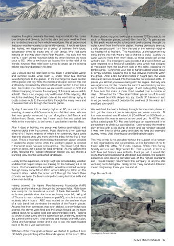
Potanin glacier; my group looking at a nameless 3763m peak, to the south of Alexander glacier, some 5-6km from BC. To gain access to this peak would involve a long and cold crossing through the water run off from the Potanin glacier. Having previously selected a safe crossing point 1km from the end of the terminal moraine, we headed off at first light. This would allow us the opportunity to cross before the melt waters had a chance to build. Luckily the water was no more then 40cm deep, so most people got across with dry feet. The initial going was good but at around 3000m we were exposed to a ferocious catabatic wind which had stripped all vegetation from the southern side of the arête, exposing the terrible scree. Everything your foot or hand touched would move or simply crumble, coursing one or two nervous moments within the group. After a few hundred meters in height gain, the winds dissipated and we moved onto the beautiful but exposed arête. In places you felt that you were soaring with the eagles. But lady luck was against us, for the route to the summit was block by seracs, some 400m from the summit, bugger. It was quite gutting having to turn from this route, a route I had coveted over a number of days. Still we had the 100m wide Potanin glacial run off to cross and it would be a little deeper too, joy. Boots off, trainers on and in we go, words can not describe the coldness of the water as it envelope your groin!
We switched the teams halfway through the mountain phase so both got the chance to undertake alpine and winter summits. All that now remained was Khuiten Uul (‘Cold Peak’) at 2000km from Ulaanbaatar this was as remote as we could get. At 4374m and with a stated grade PD, Mal was looking at an experienced three person team to climb our last objective. Unfortunately the weather duly arrived with a big dump of snow and our window passed. It was now time to strike camp and start the long but enjoyable journey home, Ulgii, Ulaanbaatar and Beijing hallo again.
This type of trip is not possible without the support of a number of key organisations and personalities, so it is beholden of me to thank: ATG HQ, AMA, RE Funds, Ulysses, RFCA, Hon Survey Society and our own Regimental HQ. Their support, in terms of both time and finance was fantastic, thank you all. I would also like to thank and recommend Mongolian Expeditions, the support, experience and catering provided was off the highest standards and I would happily recommend this company to anyone else venturing out to Mongolia. Finally, to the merry band who followed me on this journey, thank you one and all.
Capt Nessie Smith.
Crossing the Potaniin Glacier
ARMY MOUNTAINEER 47
