
Page 18 - 2000 AMA Alps
P. 18
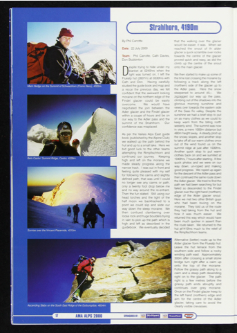
 Sunrise over the Vincent Piaramide. 4215m
Ascending Slabs on the South East Ridge of the Du/ourspitze, 4634m.
AMA ALPS 2000
SPONSOREDBY IS
M ultipart
T ransfleot
By Phil Carrotte. that the walking over the glacier would be easier, it was. When we Date: 22 July 2000 reached the snout of th alder glacier a quick scramble over rocks Team: Phil Carrotte, Cath Davies, towards the centre of the glacier Don Stubbinton proved quick and easy, as did the climb up the centre of the snout
Despite trying to hide under my onto the main glacier.
blanket at 0245hrs when the
light was turned on, I left the We then started to make up some of Fluealp hut (2607m) at 0330hrs witthe time lost crossing the moraine by
Cath and Don. Having carefully studied the guide book and map and a recce the previous day, we felt confident that the awkward looking moraine on the northern edge of the Findel glacier could be easily overcome. We would have negotiated the join between the Adler glacier and the Findel glacier within a coupe of hours and be on our way to the Adler pass and the summit of the Strahlhorn. Our confidence was misplaced.
As per the Vailais Alps East guide book (published by the Alpine Club) we walked up the path behind the hutanduptoasmalllake. Herewe bid good luck to the other teams attempting the Rimpfischhorn and continued our journey. Keeping high and left on the moraine we made steady progress along the narrowtrack. Iwasoutinfrontand feeling quite pleased with my self for following the cairns and slightly defined path, that was until I could no longer see any cairns or path, only a twenty foot drop below me and no way around the re-entrant. Then the fun stated. Still using our head torches and the light of the half moon we backtracked to a point we could slip and slide our way down the steep moraine. We then contiued clambering over loose rock and huge boulders trying in vain to pick up the path which is high and left as described in the guidebook. We eventually decided
following a track along the left (northern) side of the glacier up to the Adler pass. Here the snow steepened to around 45~. We zigzagged our way up the pass, climbing out of the shadows into the glorious morning sunshine and views over towards the eastern side of the Saas Fe valley. Despite the sunshine we had a brief stop to put on as many clothes as we could to keep warm from the biting north westerlywind. Thesummitwasnow in view, a mere 1000m distance but 480m height away. A steady plod up the snowy slopes, and another stop to take off all our warm clothes once out of the wind found us on the summit ridge at just after 1030hrs. Another quick stop to put warm clothes back on and we sumited at 1040hrs,7hoursafterstarting. Afew quick photos and we were on our way down, un-roped and making good progress. We roped up again for the descent of the Adler pass and then continued the same route down theAdlerglacier. Wetriedtofindthe path we had been searching for but failed so descended to the Flndel glacier over the right hand (northern) edge of the Alder glacier snout. Here we met two other British guys who had been biviing on the moraine. They told us of the route they had taking from the hut and how it was much easier. We returned this way which would have been much quicker in assent than theroutetaken. Wereturnedtothe hut at1415hrs much to the releif of the Rlmpflschhorn teams.
Alternative (better) route up to the Alder glacier form the Fluealp hut. Leave the hut terrace from the southern side and follow a rocky winding path east. Approximately 300m after crossing a small stone bridge turn right after a cairn up onto the top of the moraine. Follow the grassy path along to a cairn and a steep path desending right on to the glacier. The path right Is a few metres before the grassy path ends abruptly and continues over grey moraine. Once on the Findel glacier keep to the left hand (northern) edge and aim for the centre of the Adler glacier, taking care to avoid the clearly visible crevasses.
