
Page 25 - PDF Flip TR Program Demo
P. 25
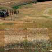
 Through the Indian Wars, the Crow tribe helped the United States Army, serving as scouts and protecting travelers on the Bozeman Trail,
which cut through this country, crossing Rosebud Creek and the Stillwater River on its way to the Yellowstone. The tribe’s first reservation was estab- lished in 1851. At 35 million acres, it encompassed thisregion, stretching from the western edge of the Absaroka-Beartooth Range east to Hysham, Montana. The swath of land south of Tippet Rise that runs east-west from the Boulder River to the Stillwater River was rumored to contain copper, nickel, and chromium. Miners arrived and staked their claims there and elsewhere in the region,
and the Crow reservation was reduced to 8 million acres. From 1875 to 1884, the reservation’s headquarters, known as the Crow Agency, was located 3 miles south of present-day Absarokee, near the turnoff from Highway 78 to Fishtail and Tippet Rise.
Between the tribe’s dwindling lands and the rapid destruction of the bison, the Crow people’s nomadic way of life also dwindled, and then ended. Eventually, the tribe was forced to cede yet more land and was pushed out of the Stillwater Valley 60 miles east, to the high plains south of Billings. As the Crow people moved out, settlers moved in. The Free Homestead Act entitled each homesteader to a quarter section of land, or 160 acres. It’s easy to imagine that there might have been 50 or 60 different homestead claims staked on the land that is now Tippet Rise. But this country
is windy, exposed, and arid—difficult to carve a life from—and many settlers deserted their claims, leaving little behind. Three of the canyons of Tippet Rise were each named for a homesteading family: the Lannan, the Arnie, and the Murphy. Our ranch manager, Ben Wynthein, is building a timber-framed period cabin
on the footprint of one of the settlers’ homes, which burned to the ground in the mid-1950s.
 2018 Summer Season 25
