Page 258 - Geosystems An Introduction to Physical Geography 4th Canadian Edition
P. 258
 222 part II The Water, Weather, and Climate Systems
  CriTiCALthinking 8.1 Analyzing a Weather Map
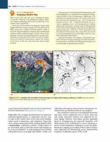
After studying the text, test your knowledge by deter- mining the conditions in Fort McMurray, Calgary, Saska- toon, regina, Winnipeg, and Toronto as depicted on the weather map in Figure 8.12.
Next, look at the weather map showing a classic open stage midlatitude cyclone in Figure CT 8.1.1 for February 19, 2004, along with a GOES-12 infrared satellite image at that time. Using the legend in Figure 8.12 for weather map symbols, briefly analyze this map: Find the centre of low pressure, note the counterclockwise winds, compare tem- peratures on either side of the cold front, note air temper- atures and dew-point temperatures, explain the location of the fronts on the map, and locate the centre of high pressure.
(a) (b)
Think about the air and dew-point temperatures in the great Lakes Basin as compared to those along the Atlantic coast. At 8:00 a.m., the air temperature in Halifax was −4°C and dew-point temperature was −4°C, while in Toronto at the same time the temperature was −4°C and dew-point temperature was −6°C. To become saturated, the air in Toronto needed to cool to −6°C, whereas the air in Halifax was already at saturation. in the far north, find Kuujjuarapik on the eastern shore of Hudson Bay. The air and dew-point temperatures were −23°C and −27°C, respectively, and the state of the sky was clear. if you were there, what would you have experienced at this time? Why would you have been reaching for the lip balm?
Describe the pattern of air masses on this weather map. How are these air masses interacting, and what kind of fron- tal activity do you see? What does the pattern of isobars tell you about high- and low-pressure areas? •
    ▲Figure CT 8.1.1 Weather map and GOES-12 infrared image over eastern North America, February 19, 2004. [(a) Satellite GOES-12 image courtesy of NOAA. (b) Map data from environment Canada.]
events and aviation hazards such as clear-air turbulence (for more information, see rapidrefresh.noaa.gov/).
Supercells The strongest thunderstorms are known as supercell thunderstorms, or supercells, and give rise to some of the world’s most severe and costly weather events (such as hailstorms and tornadoes). Supercells often contain a deep, persistently rotating updraft called a mesocyclone, a spinning, cyclonic, rising column of air associated with a convective storm and ranging up to 10 km in diametre. A well-developed mesocyclone will produce heavy rain, large hail, blustery winds, and
lightning; some mature mesocyclones will generate tor- nado activity (as discussed later in this chapter).
The conditions conducive to forming thunderstorms and more intense supercells—lots of warm, moist air and strong convective activity—are enhanced by cli- mate change. However, wind shear, another important factor in thunderstorm and supercell formation, will likely lessen in the midlatitudes as Arctic warming re- duces overall temperature differences across the globe. Research is ongoing as to which of these effects will be more important for determining severe thunderstorm frequency in different regions of the world.


