Page 293 - Geosystems An Introduction to Physical Geography 4th Canadian Edition
P. 293
 consideration in many regions is that groundwater accu- mulation occurred over millions of years, so care must be taken not to deplete this long-term buildup with exces- sive short-term demands.
Groundwater provides about 80% of the world’s irrigation water for agriculture and nearly half the world’s drinking water. It is generally free of sediment, colour, and disease organisms, although polluted groundwater conditions are considered irreversible. Where groundwa- ter pollution does occur, it threatens water quality. Over- consumption is another problem, depleting groundwater volume in quantities beyond natural replenishment rates and thus threatening global food security.
About 50% of the U.S. population derives a portion of its freshwater from groundwater sources. In some states, such as Nebraska, groundwater supplies 85% of water needs, with that figure as high as 100% in rural areas.
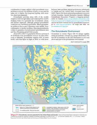
Between 1950 and 2000, annual groundwater withdrawal in Canada and the United States increased more than 150%. Figure 9.16 shows potential groundwater resources in both countries. Natural Resources Canada’s (NRCan) Groundwater Geoscience Program is mapping ground- water in Canada (www.nrcan.gc.ca/earth-sciences/resources/ federal-programs/groundwater-geoscience-program/10909) and for the latest research on U.S. groundwater resources, go to water.usgs.gov/ogw/gwrp/; for maps and data, see groundwaterwatch.usgs.gov/.
The Groundwater Environment
Geosystems in Action, Figure GIA 9.1 brings together many groundwater concepts in a single illustration. Fol- low the 13 numbers on the GIA illustration as you read about each part of the groundwater environment.
60°
50°
50°
40°
40°
PACIFIC OCEAN
ATLANTIC OCEAN
200 400 KILOMETRES
70°
CANADA (Aquifer potential 0.4 L · s–1)
Productive aquifer
30°
30°
Tr
o
pi
c
o
f
C
120°
UNITED STATES (Aquifer potential 3.33 L · s–1)
Gulf of Mexico
90° 80°
Consolidated rock aquifers: Mostly volcanic rocks in the Northwest, mostly sandstone and limestone elsewhere.
Combination aquifers: Sand and gravel aquifers overlying productive rock aquifers.
Watercourse: Productive aquifer adjacent to and capable of replenishment by perennial streams.
Unconsolidated aquifers: Mostly sand and gravel.
HIGH PLAINS AQUIFER
▲Figure 9.16 Groundwater resource potential for the United States and Canada. areas of the United States indicated in dark blue are underlain by productive aquifers capable of yielding freshwater to wells at 3.33 l · s−1 or more (for Canada, 0.4 l · s−1). [Courtesy of Water resources Council for the United States and the inquiry on Federal Water Policy for Canada.]
Hudson Bay
Chapter 9 Water resources 257
(text continued on page 260)
0
a
nc
er


