Page 319 - Geosystems An Introduction to Physical Geography 4th Canadian Edition
P. 319
     Chapter 10 Global Climate Systems 283
 ITCZ
35.0 38
32.5 32
30.0 27
27.5 21
25.0 16
22.5 10
20.0 4
0
–1
7.5 –23 5.0 –29 2.5 –34
–40 JFMAMJJASOND
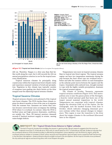
Month (a) Climograph for Uaupés, Brazil.
Station: Uaupés, Brazil Lat/long: 0° 06′ S 67° 02′ W Avg. Ann. Temp.: 25°C Total Ann. Precip.: 291.7 cm Elevation: 86 m Population: 10 000
Ann. Temp. Range: 2 C° Ann. Hr of Sunshine: 2018
Uaupés
BRAZIL
1000 KILOMETRES
      80°
60° 50° 40°
  10°
   20° 30°
0° 10°
0°
       20°
    Precipitation (cm)
Temperature (°C)
   30°
 50°
0
▲Figure 10.3 Tropical rain forest climate. [(b) Sue Cunnigham Photographic/alamy.]
269 cm. Therefore, Yangon is a drier area than that far- ther north along the coast, but it still exceeds the 250-cm annual precipitation criterion in use for the tropical mon- soon classification.
Tropical monsoon climates lie principally along coastal areas within the tropical rain forest climatic realm and experience seasonal variation of wind and precipita- tion. Vegetation in this climate type typically consists of evergreen trees grading into thorn forests on the drier margins near the adjoining tropical savanna climates.
tropical savanna Climates
Tropical savanna climates exist poleward of the tropical rain forest climates. The ITCZ reaches these climate re- gions for about 6 months or less of the year as it migrates with the summer Sun. Summers are wetter than win- ters because convectional rains accompany the shifting ITCZ when it is overhead. In contrast, when the ITCZ is farthest away and high pressure dominates, conditions are notably dry. Thus, PE (natural moisture demand) exceeds P (natural moisture supply) in winter, causing water-budget deficits.
Temperatures vary more in tropical savanna climates than in tropical rain forest regions. The tropical savanna regime can have two temperature maximums during the year because the Sun’s direct rays are overhead twice— before and after the summer solstice in each hemisphere as the subsolar point moves between the equator and the tropics. Grasslands with scattered trees, drought resistant to cope with the highly variable precipitation, dominate the tropical savanna regions.
The climate of Arusha, Tanzania, represents tropical savanna conditions (Figure 10.5). This metro- politan area is near the grassy plains of the Serengeti, a heavily visited national park that hosts one of the largest annual mammal migrations in the world. Temperatures are consistent with tropical climates, despite the elevation (1387 m) of the station. On the climograph, note the marked dryness from June to October, which indicates changing dominant pres- sure systems rather than annual changes in temper- ature. This region is near the transition to the drier desert hot steppe climates to the northeast (discussed later in the chapter).
(b) The rain forest along a tributary of the Rio Negro River, Amazonas state, Brazil.
0
 17.5
15.0 –7 12.5 –12 10.0 –18
 Georeport 10.1 tropical Climate Zones advance to higher latitudes
The belt of tropical climates that straddles the equator is getting wider. recent research suggests that this zone has widened more than 2° of latitude since 1979, with an overall advance of 0.7° of latitude per decade. evidence indicates that
the southward advance of this climate boundary is affected by stratospheric ozone depletion over the antarctic region, while the northward advance relates to increases in black carbon aerosols and tropospheric (ground layer) ozone caused by fossil fuel burning in the Northern Hemisphere—these pollutants absorb sunlight and warm the atmosphere. as the tropical climates move poleward, the dry subtropical regions are becoming drier, with more frequent droughts.


