Page 390 - Geosystems An Introduction to Physical Geography 4th Canadian Edition
P. 390
 354 part III The Earth–Atmosphere Interface
 Mountain
Moho
Displacement
Low-density mountain “root”
Oceanic crust Ocean
Uppermost mantle (rigid) Asthenosphere (plastic)
that circulation in the outer core con- verts thermal and gravitational energy into magnetic energy, thus producing the magnetic field. The locations of the north and south magnetic poles are surface expressions of Earth’s magnetic field and migrate as plotted on the map in Geosystems Now for this chapter.
At various times in Earth’s history, the magnetic field has faded to zero and then returned to full strength with the polarity reversed (meaning that the north magnetic pole then lies near the south geographic pole, so that a compass nee- dle would point south). In the process, the field does not blink on and off but in- stead diminishes slowly to low intensity, perhaps 25% strength, and then rapidly regains full power. This geomagnetic reversal has taken place nine times dur- ing the past 4 million years and hundreds of times over Earth’s history. During the transition interval of low strength, Earth’s surface receives higher levels of cosmic radiation and solar particles, but not to such an extent as to cause species extinctions. Life on Earth has weathered many of these transitions.
The average period of a magnetic reversal is about 500000 years, rang- ing from as short as 20000 years to as long as 50 million years. The last rever- sal was 790000 years ago, preceded by a transition ranging from 2000 years in length along the equator to 10000 years in the midlatitudes. Given rates of mag- netic field decay measured over the last 150 years, we are perhaps 1000 years away from entering the next phase of field changes, although there is no ex- pected pattern to forecast the timing.
The reasons for these magnetic re- versals are unknown. However, they have become a key tool in understand- ing the evolution of landmasses and the movements of the continents. As rocks cool and solidify from molten mate- rial (lava) at Earth’s surface, the small magnetic particles in the material align according to the orientation of the mag- netic poles at that time, and this align- ment locks in place.
  Continental crust Lithosphere
in upper mantle
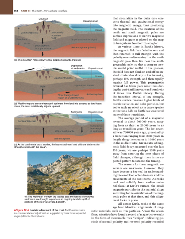
(a) The mountain mass slowly sinks, displacing mantle material.
Deposition of sediments
Oceanic crust Ocean
      Uplift
Uppermost mantle
Granitic intrusions
Slow flowage toward region of crustal thinning
Asthenosphere
(b) Weathering and erosion transport sediment from land into oceans; as land loses mass, the crust isostatically adjusts upward.
   Continental crust Moho
Sediments
Uppermost mantle
Asthenosphere
Oceanic crust
Ocean
Subsidence from weight of sediments
(c) As the continental crust erodes, the heavy sediment load offshore deforms the lithosphere beneath the ocean.
(d) The melting of ice from the last ice age and losses of overlying sediments are thought to produce an ongoing isostatic uplift of portions of the Sierra Nevada batholith.
  ▲Figure 12.4 Isostatic adjustment of the crust. Earth’s entire crust is in a constant state of adjustment, as suggested by these three sequential stages. [(d) Bobbé Christopherson.]
All across Earth, rocks of the same age bear identical alignments of mag- netic materials, such as iron particles. Across the ocean floor, scientists have found a record of magnetic reversals in the form of measurable rock “stripes” indicating pe- riods of normal polarity and reversed polarity recorded


