Page 407 - Geosystems An Introduction to Physical Geography 4th Canadian Edition
P. 407
Chapter 12 The Dynamic Planet 371
       Offshore Insular Belt Coast Belt
     Depth (km) 0
20 40 60 80
100
Strait of Pacific Ocean Vancouver Island Georgia
Vancouver
Fraser River
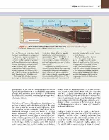
           ▲Figure 12.1.2 Plate tectonic setting of the Cascadia subduction zone. [Cross section adapted courtesy of LITHOPROBE Secretariat, The University of British Columbia, www.lithoprobe.ca.]
the city of Vancouver. Long, deep fjords that were created by glacial erosion dur- ing Pleistocene glaciations dissect the mountain ranges. The bedrock consists largely of granite in the form of plutons and batholiths that intrude into folded, faulted, and metamorphosed volcanic and sedimentary rocks. The granitic rocks represent the roots of deeply eroded volcanoes that formed at vari- ous times throughout the Mesozoic and early Cenozoic eras (170 to 45 m.y.a.).
The Insular Belt includes the moun- tain ranges on Vancouver Island and
Haida Gwaii (Queen Charlotte Islands),
as well as the rocks that underlie the continental shelf (Figure 12.1.2). This belt is composed of Paleozoic and Mesozoic volcanic and sedimentary rocks that have been intruded by Mesozoic and Cenozoic granitic rocks.
The presence of youthful mountain ranges in both the Insular and Coast belts underlain by metamorphosed Paleozoic rocks and Mesozoic and Cenozoic gra- nitic intrusions records a second phase of mountain building (84 to 40 m.y.a.). This phase is associated with the accretion of
exotic terranes along the western margin of North America.
The Pacific Ocean floor started
to move strongly northward along
the margin of the advancing North American plate about 85 m.y.a. Portions of the North American plate became coupled with the underlying oceanic plate and started to move northward with it. This movement caused widespread faulting within the Western Cordillera and the displacement of accreted ter- ranes several hundreds of kilometres northward.
Magma
Continental crust
 Continental mantle
 Metamorphic rocks
plate motion. In the case of a fixed hot spot, the area of a plate that passes above it is locally heated for the brief geologic time it remains above that spot (a few hundred thousand or million years), sometimes producing a chain of volcanic features.
Hydrothermal Features Groundwater that is heated by pockets of magma and other hot portions of the crust may emerge as a hot spring or erupt explosively from the ground as a geyser—a spring characterised by in- termittent discharge of water and steam. A hot spot below Yellowstone National Park in Montana and Wyoming produces several types of hydrothermal fea- tures, including geysers, mud pots, and fumaroles (see The Human Denominator, Figure HD 12a). Mud pots are bubbling pools that are highly acidic with limited water supply, and thus produce mainly gases that are
broken down by microorganisms to release sulfuric acid, which in turn breaks down rock into clays that form mud. As gases escape through the mud, they pro- duce the bubbling action that makes these features dis- tinct. Fumaroles are steam vents that emit gases that may contain sulfur dioxide, hydrogen chloride, or hy- drogen sulfide—some areas of Yellowstone are known for the characteristic odour of “rotten eggs” caused by hydrogen sulfide gas.
Hot-Spot Island Chains A hot spot in the Pacific Ocean produced, and continues to form, the Hawaiian– Emperor Islands chain, including numerous sea- mounts, which are submarine mountains that do not reach the surface (Figure 12.22). The Pacific plate moved across this hot, upward-erupting plume over the last 80 million years, creating a string of volcanic
O
c
e
a
n
i
c
r o
r
c
a
L
s
c A
i
w t
u e
h
e
s o
t
n
t e
o
n o
c s
li p
h h
e
s e
p r
r
h e
e


