Page 430 - Geosystems An Introduction to Physical Geography 4th Canadian Edition
P. 430
 394 part III The Earth–Atmosphere Interface
 block (see Figure 13.8). Place your hands palms-down on your desk, with fingertips together, and slide one hand up over the other—this is the motion of a low-angle thrust fault, with one side pushing over the other.
In the Alps, several such overthrusts have resulted from compressional forces of the ongoing collision be- tween the African and Eurasian plates. Beneath the Los Angeles Basin, overthrust faults caused numerous earthquakes in the twentieth century, including the $30 billion 1994 Northridge earthquake. Many of the faults beneath the Los Angeles region are “blind thrust faults,” meaning that no evidence of rupture exists at the surface. Such faults are essentially buried under the crust but remain a major earthquake threat.
When lateral shear causes horizontal movement along a fault plane, such as produced along a transform plate boundary and the associated transform faults, the fault is called a strike-slip fault (Figure 13.11c). The movement is right lateral or left lateral, depending on the direction of motion an observer on one side of the fault sees occurring on the other side.
The San Andreas fault system is a famous example of both a transform and strike-slip fault. Recall from Chap- ter 12 that transform faults occur along transform plate boundaries; most are found in the ocean basins along mid-ocean ridges, but some cross continental crust. The crust on either side of a transform fault moves parallel to the fault itself; thus, transform faults are a type of strike- slip fault. However, since some strike-slip faults occur at locations away from plate boundaries, not all strike-slip faults are transform.
Along the western margin of North America, plate boundaries take several forms. The San Andreas trans- form fault is the product of a continental plate (the North American plate) overriding an oceanic transform plate boundary. The San Andreas fault meets a seafloor spreading centre and a subduction zone at the Men- docino Triple Junction (a triple junction is where three plates intersect). Each of these plate boundaries is illus- trated in Figure 13.12a.
Strike-slip faults often create linear valleys, or troughs, along the fracture zone, such as those along the San Andreas (Figure 13.12b). Offset streams are another landform associated with strike-slip faults, character- ised by an abrupt bend in the course of the stream as it crosses the fault.
Faulted Landscapes Across some landscapes, pairs of faults act in concert to form distinctive terrain. The term horst applies to upward-faulted blocks; graben refers to downward-faulted blocks (Figure 13.13). The Great Rift Valley of East Africa, associated with crustal spreading, is an example of such a horst-and-graben landscape. This rift extends northward to the Red Sea, which fills the rift formed by parallel normal faults. Lake Baikal in Siberia, discussed in the Chapter 9 Geosystems Now, is also a gra- ben. This lake basin is the deepest continental “rift val- ley” on Earth and continues to widen at an average rate of about 2.5 cm per year. Another example, among many, is
the Rhine graben, through which the Rhine River flows in Europe. Go to the MasteringGeography website for photos and images of these landscapes.
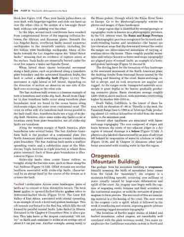
A large region that is identified by several geologic or topographic traits is known as a physiographic province. In the U.S. interior west, the Basin and Range Province is a physiographic province recognized for its north-and- south-trending basins and mountains—the basins are low-elevation areas that dip downward toward the centre the ranges are interconnected mountains of varying el- evations above the basins. These roughly parallel moun- tains and valleys (known as basin-and-range topography) are aligned pairs of normal faults, an example of a horst- and-graben landscape (Figure 13.14a and b).
The driving force for the formation of this landscape is the westward movement of the North American plate; the faulting results from tensional forces caused by the uplifting and thinning of the crust. Basin-and-range re- lief is abrupt, and its rock structures are angular and rugged. As the ranges erode, transported materials accu- mulate to great depths in the basins, gradually produc- ing extensive plains. Basin elevations average roughly 1200–1500 m above sea level, with mountain crests rising higher by another 900–1500 m.
Death Valley, California, is the lowest of these ba- sins, with an elevation of –86 m. Directly to the west, the Panamint Range rises to 3368 m at Telescope Peak, produc- ing almost 3.5 vertical kilometres of relief from the desert valley to the mountain peak.
Several other landforms are associated with basin- and-range topography. The area composed of slopes and basin between the crests of two adjacent ridges in a dry region of internal drainage is a bolson (Figure 13.14b). A playa is a dry lakebed characterised by an area of salt crust left behind by evaporation of water in a bolson or valley (Figure 13.14c and d). Chapter 15 discusses other land- forms associated with running water in this dry region.
Orogenesis (Mountain Building)
The geologic term for mountain building is orogenesis, literally meaning the birth of mountains (oros comes from the Greek for “mountain”). An orogeny is a mountain-building episode, occurring over millions of years, usually caused by large-scale deformation and uplift of the crust. An orogeny may begin with the cap- ture of migrating exotic terranes and their accretion to the continental margins, or with the intrusion of granitic magmas to form plutons. The net result of this accumulat- ing material is a thickening of the crust. The next event in the orogenic cycle is uplift, which is followed by the work of weathering and erosion, exposing granite plutons and creating rugged mountain topography.
The locations of Earth’s major chains of folded and faulted mountains, called orogens, are remarkably well correlated with the plate tectonics model. Two major ex- amples are the Cordilleran mountain system in North and


