Page 522 - Geosystems An Introduction to Physical Geography 4th Canadian Edition
P. 522
 AQuantitativeSOLUTIOn Flood Frequency Analysis
The degree to which any phenomenon is a hazard depends on its magnitude and its frequency of occurrence. The frequency with which a flood of a certain magnitude or higher can be expected to occur is called its recurrence interval. Recurrence intervals can be determined wherever long-term river-gauging records are available, and are given by the formula:
T = (n + 1) rm
where Tr is the recurrence interval, n is the number of years of record, and m is the number of floods of the given magnitude or higher during the years of record.
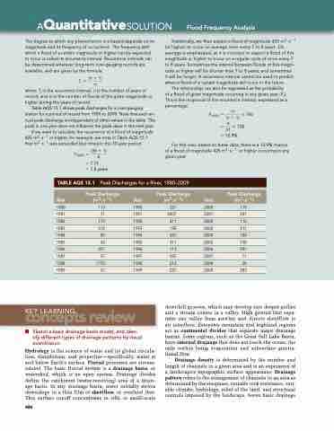
Table AQS 15.1 shows peak discharges for a river-gauging station for a period of record from 1980 to 2009. Note that each an- nual peak discharge is independent of other values in the table. The peak in one year does not influence the peak value in the next year.
If we want to calculate the recurrence of a flood of magnitude 425 m3 · s−1 or higher, for example, we note in Table AQS 15.1 that m3 · s−1 was exceeded four times in the 30-year period.
Tr (425) = (30 + 1) 4
= 7.75
= 7.8 years
Statistically, we then expect a flood of magnitude 425 m3 · s−1 (or higher) to occur on average once every 7 to 8 years. On average is emphasized, as it is incorrect to expect a flood of this magnitude or higher to occur on a regular cycle of once every 7 to 8 years. Sometimes the interval between floods of this magni- tude or higher will be shorter than 7 to 8 years, and sometimes
it will be longer. A recurrence interval cannot be used to predict when a flood of a certain magnitude will occur in the future.
The relationship can also be expressed as the probability of a flood of given magnitude occurring in any given year (Pr ). This is the reciprocal of the recurrence interval, expressed as a percentage:
Pr(425) = m * 100 (n + 1)
= 4 * 100 31
= 12.9%
For this river, based on these data, there is a 12.9% chance of a flood of magnitude 425 m3 · s−1 or higher occurring in any given year.
 TABLe AQS 15.1
Peak Discharges for a River, 1980–2009
 Year
Peak Discharge (m3 ∙ s−1)
Year
Peak Discharge (m3 ∙ s−1)
Year
Peak Discharge (m3 ∙ s−1)
1980 113 1982 170 1984 85 1986 297 1988 1770
1990 227 2000 119 1992 411 2002 112 1994 255 2004 184 1996 113 2006 991 1998 212 2008 28
 1981
  71
  1991
  2407
  2001
  241
   1983
  212
  1993
  198
  2003
  311
  1985
  42
  1995
  311
  2005
  198
  1987
  57
  1997
  595
  2007
  71
  1989
  57
  1999
  227
  2009
  283
  concepts review
KEy LEARnIng
   ■ Sketch a basic drainage basin model, and iden- tify different types of drainage patterns by visual examination.
Hydrology is the science of water and its global circula- tion, distribution, and properties—specifically, water at and below Earth’s surface. Fluvial processes are stream- related. The basic fluvial system is a drainage basin, or watershed, which is an open system. Drainage divides define the catchment (water-receiving) area of a drain- age basin. In any drainage basin, water initially moves downslope in a thin film of sheetflow, or overland flow. This surface runoff concentrates in rills, or small-scale
486
downhill grooves, which may develop into deeper gullies and a stream course in a valley. High ground that sepa- rates one valley from another and directs sheetflow is an interfluve. Extensive mountain and highland regions act as continental divides that separate major drainage basins. Some regions, such as the Great Salt Lake Basin, have internal drainage that does not reach the ocean, the only outlets being evaporation and subsurface gravita- tional flow.
Drainage density is determined by the number and length of channels in a given area and is an expression of a landscape’s topographic surface appearance. Drainage pattern refers to the arrangement of channels in an area as determined by the steepness, variable rock resistance, vari- able climate, hydrology, relief of the land, and structural controls imposed by the landscape. Seven basic drainage


