Page 552 - Geosystems An Introduction to Physical Geography 4th Canadian Edition
P. 552
 516 part III The Earth–Atmosphere Interface
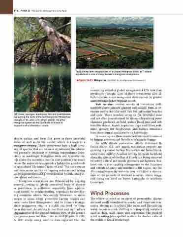
     (a) Corals, sponges, anemones, fish and invertebrates live among the roots of the red mangrove (Rhizophora mangle) in St. John, U.S. Virgin Islands. No other mangrove system in the Caribbean is known to support such a diversity of corals.
shrubs, palms, and ferns that grow in these intertidal areas, as well as for the habitat, which is known as a mangrove swamp. These ecosystems have a high diver- sity of species that are tolerant of saltwater inundation but generally intolerant of freezing temperatures (espe- cially as seedlings). Mangrove roots are typically vis- ible above the waterline, but the root portions that reach below the water surface provide a habitat for a multitude of specialized life forms (Figure 16.23a). The root systems maintain water quality by trapping sediment and taking up excess nutrients and prevent erosion by stabilizing ac- cumulated sediments.
Mangrove ecosystems are threatened by ongoing removal, owing to falsely conceived fears of disease or pestilence; to pollution, especially from agricul- tural runoff; to overharvesting, especially in develop- ing countries where they supply firewood; to storm surges in areas where protective barrier islands and coral reefs have disappeared; and to climate change, since mangroves require a stable sea level for long- term survival. According to the Food and Agriculture Organization of the United Nations, 20% of the world’s mangroves were lost from 1980 to 2005 (Figure 16.23b). A 2011 study using satellite data reported that the
(b) A shrimp farm occupies part of a cleared mangrove forest in Thailand; aquaculture is one of many threats to mangrove ecosystems.
▲Figure 16.23 Mangroves. [(a) USGS. (b) think4photop/Shutterstock.]
remaining extent of global mangroves is 12% less than previously thought. Loss of these ecosystems also af- fects climate, since mangroves store carbon in greater amounts than other tropical forests.
Salt marshes consist mainly of halophytic (salt- tolerant) plants (mainly grasses) and usually form in es- tuaries and in the tidal mud flats behind barrier beaches and spits. These marshes occur in the intertidal zone and are often characterised by sinuous, branching water channels produced as tidal waters flood into and ebb from the marsh. Marsh vegetation traps and filters sedi- ment, spreads out floodwaters, and buffers coastlines from storm surges associated with hurricanes.
In many regions these coastal wetlands are threatened by human activities and the effects of climate change.
As with stream restoration efforts discussed in Focus Study 15.1, salt marsh restoration projects are growing in number. In New Brunswick and Nova Scotia, some dikes built by Acadian settlers to create farmland along the shores of the Bay of Fundy are being removed to restore natural salt marsh processes and habitats. Sea- level rise is also causing adjustments in the locations and extents of many salt marshes in the region. On the MasteringGeography website, you will find a discus- sion of the impacts of wetland removal, storm surge, and rising sea level on Bayou Lafourche in southern Louisiana.
Wind Processes
The effects of wind as an agent of geomorphic change are most easily visualized in coastal and desert environ- ments. Moving air is a fluid, like water, and like moving water, causes erosion, shifting or transporting materials such as dust, sand, snow, and deposition. The work of wind is eolian (also spelled aeolian, for Aeolus, ruler of the winds in Greek mythology).


