Page 571 - Geosystems An Introduction to Physical Geography 4th Canadian Edition
P. 571
 which can sometimes be large enough to destroy forests or entire mountain villages (see Focus Study 17.1).
Formation of Glacial Ice
In some regions on Earth, snow is permanent on the land- scape, and it is in those regions—both at high latitudes and at high elevations at any latitude—that glaciers form. As mentioned in Chapter 5, a snowline is the lowest ele- vation where snow remains year-round; specifically, it is the lowest line where winter snow accumulation persists throughout the summer. On equatorial mountains, the snowline is around 5000 m above sea level; on midlati- tude mountains, such as the European Alps, snowlines average 2700 m; and in southern Greenland, snowlines are as low as 600 m.
Glaciers form by the continual accumulation of snow that recrystallizes under its own weight into an ice mass. Ice, in turn, is both a mineral (an inorganic natural com- pound of specific chemical makeup and crystalline struc- ture) and a rock (a mass of one or more minerals). As mentioned earlier, the accumulation of snow in layered deposits is similar to the layering in sedimentary rock. To give birth to a glacier, snow and ice are transformed under pressure, recrystallizing into a type of metamorphic rock.
Consider that as snow accumulates during the win- ter, the increasing thickness results in increased weight and pressure on the underlying layers. In summer, rain and snowmelt contribute water, which stimulates further melting, and this meltwater seeps down into the snow- field and refreezes. Air spaces between ice crystals are compressed as the snow packs to a greater density, re- crystallizing and consolidating as the pressure continues to increase. Through this process, snow that survives the summer and is still present the following winter begins a slow transformation into glacial ice. In a transition step, the snow becomes firn, a granular, partly compacted snow that is intermediate between snow and ice.
Dense glacial ice is produced over a period of many years as this process continues. In Antarctica, glacial ice formation may take 1000 years because of the dryness of the climate and minimal snowfall, whereas in wet cli- mates, the time is reduced to several years because of constant heavy snowfall.
Types of Glaciers
A glacier is defined as a large mass of ice resting on land or floating in the sea attached to a landmass (the latter is an ice shelf, discussed in Geosystems Now section and later in the chapter). Glaciers are not stationary; they move under the pressure of their own great weight and the pull of gravity. In fact, they move in streamlike pat- terns, merging as tributaries into large rivers of ice that slowly flow outward toward the ocean (see Figure 17.1). For an inventory of world glaciers, go to glims.colorado.edu/ glacierdata/db_summary_stats.php or to www.wgms.ch.
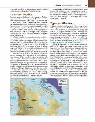
Although glaciers are as varied as the landscape it- self, they fall within two general groups, based on their form, size, and flow characteristics: alpine glaciers and continental ice sheets (also called continental glaciers). Ice sheets, which occur mainly in Greenland and Antarc- tica, are extensive areas of glacial ice that cover large land- masses. Today, alpine glaciers and ice sheets cover about 10% of Earth’s land area, ranging from the polar regions to midlatitude mountain ranges to some of the high moun- tains along the equator, such as in the Andes Mountains of South America and on Mount Kilimanjaro in Tanza- nia, Africa. Canada’s ice, found in alpine glaciers and ice caps, makes up 1.2% of the world’s perennial ice in an area totalling about 200000 km2. Canada’s glacial regions can be classified as Arctic, Coastal, and Rocky Mountain (Figure 17.2). During colder climate episodes in the past, glacial ice covered as much as 30% of continental land. Throughout these “ice ages,” below-freezing temperatures
60°
150°
PACIFIC OCEAN
135°
Coastal
Arctic
Hudson Bay
CANADA GLACIERS
Glaciers
30°
ATLANTIC 45° OCEAN
0 250
500 KILOMETRES
60°
165°
ARCTIC OCEAN
CANADA
Rocky Mountain
◀Figure 17.2 Glacial ice in Canada. regions of glacial ice in Canada can be described as Coastal, arctic, and rocky Mountain. [Map courtesy of Canadian Geographic.]
Chapter 17 glacial and Periglacial Landscapes 535
5
4
45°


