Page 574 - Geosystems An Introduction to Physical Geography 4th Canadian Edition
P. 574
 538 part III The earth–atmosphere interface
   N
Cirque glacier
glacier
Xuelian Feng
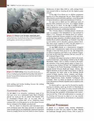
▲Figure 17.3 Glaciers in the Tien Shan, central Asia, 2011. Photo location is in the central Tien Shan, north of the Himalayas and just east of the meeting of the borders of China, Kazakhstan, and Kyrgyzstan. [ISS astronaut photo, naSa/gSC.]
▲Figure 17.4 Glacial calving, active calving fills the sea with brash ice, bergy bits, and icebergs along the edge of the austfonna ice Cap on nordaustlandet island in the archipelago of Svalbard, norway. The glacial front retreated about 2 km from 2012 to 2013. [Bobbé Christopherson.]
with melting and further breakup (review the iceberg discussion in Chapter 7).
Continental Ice Sheets
An ice sheet is an extensive, continuous mass of ice that may occur on a continental scale. Most of Earth’s glacial ice exists in the ice sheets that blanket 81% of Greenland—1 756 000 km2 of ice—and 90% of Antarctica—14.2 million km2 of ice. Antarctica alone contains 92% of all the glacial ice on the planet (review the ice volumes in the chapter introduction).
The ice sheets of Antarctica and Greenland have such enormous mass that large portions of each land- mass beneath the ice are isostatically depressed (pressed down by weight) below sea level. Each ice sheet reaches
thicknesses of more than 3000 m, with average thick- ness around 2000 m, burying all but the highest peaks of land.
At the edge of ice sheets are ice shelves, permanent masses of ice that extend into the sea. These shelves are often found in protected inlets and bays, cover thousands of square kilometres, and reach thicknesses of 1000 m.
Ice caps and ice fields are two additional types of glaciers with continuous ice cover, on a slightly smaller scale than an ice sheet. An ice cap is roughly circular and, by definition, covers an area of less than 50 000 km2, completely burying the underlying landscape.
The volcanic island of Iceland features several ice caps; an example is the Vatnajökull Ice Cap outlined in Figure 17.5a. Volcanoes lie beneath these icy surfaces. Iceland’s Grímsvötn Volcano erupted in 1996 and 2004, producing large quantities of melted glacial water in a sudden flood called a jökulhlaup, an Icelandic term that is now widely used to describe a glacial outburst flood. The most recent eruption in 2011 was the largest in a century but did not produce an outburst flood.
An ice field extends in a characteristic elongated pattern over a mountainous region and is not extensive enough to form the dome of an ice cap. The Patagonian ice field of Argentina and Chile is one of Earth’s largest. It is only 90 km wide but stretches 360 km, from 46° to 51° S latitude (Figure 17.5b).
In Canada, the largest non-polar ice field in the world, at about 18000 km2, is the Kluane Icefield in the St. Elias Mountains, Yukon. This ice field is located at the north- ern extremity of the Coastal glacial region in Figure 17.2. Covering an area of about 325 km2, the Columbia Icefield is the largest in the Rocky Mountains, straddling the con- tinental divide between Banff and Jasper, Alberta. The highest elevation on the ice field, Snow Dome, is 3520 m and represents the triple point in the drainage divide system of North America: Arctic, Atlantic, and Pacific. Eight glaciers flow from the ice field, including the Atha- basca, Saskatchewan, Dome, Stutfield, Castleguard, and Columbia. Other ice fields in Canada are found in the Coast Mountains in British Columbia and on islands in the High Arctic.
Ice sheets and ice caps may be drained by rapidly moving ice streams, made up of solid ice that flows at a faster rate than the main ice mass toward lowland areas or the sea. For example, a number of ice streams flow through the periphery of Greenland and Antarc- tica (review Fig. 17.1b). An outlet glacier is a stream of ice flowing out from an ice sheet or ice cap, usually constrained on each side by the bedrock of a mountain valley.
Glacial Processes
A glacier is a dynamic body, moving relentlessly downslope at rates that vary within its mass, shaping the landscape through which it flows. Like so many of
Peak 6231 Valley


