Page 580 - Geosystems An Introduction to Physical Geography 4th Canadian Edition
P. 580
 544 part III The earth–atmosphere interface
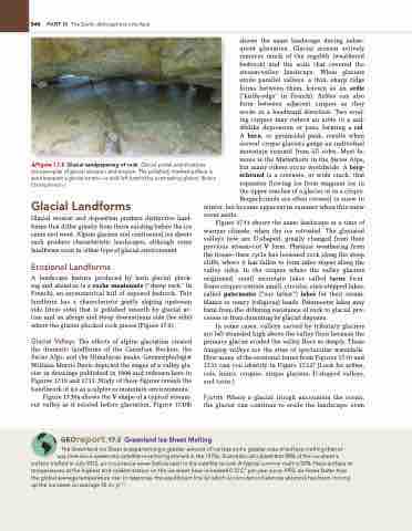
  ▲Figure 17.8 Glacial sandpapering of rock. glacial polish and striations
are examples of glacial abrasion and erosion. The polished, marked surface is seen beneath a glacial erratic—a rock left behind by a retreating glacier. [Bobbé Christopherson.]
shows the same landscape during subse- quent glaciation. Glacial erosion actively removes much of the regolith (weathered bedrock) and the soils that covered the stream-valley landscape. When glaciers erode parallel valleys, a thin, sharp ridge forms between them, known as an arête (“knife-edge” in French). Arêtes can also form between adjacent cirques as they erode in a headward direction. Two erod- ing cirques may reduce an arête to a sad- dlelike depression or pass, forming a col. A horn, or pyramidal peak, results when several cirque glaciers gouge an individual mountain summit from all sides. Most fa- mous is the Matterhorn in the Swiss Alps, but many others occur worldwide. A berg- schrund is a crevasse, or wide crack, that separates flowing ice from stagnant ice in the upper reaches of a glacier or in a cirque. Bergschrunds are often covered in snow in
Glacial Landforms
Glacial erosion and deposition produce distinctive land- forms that differ greatly from those existing before the ice came and went. Alpine glaciers and continental ice sheets each produce characteristic landscapes, although some landforms exist in either type of glacial environment.
Erosional Landforms
A landscape feature produced by both glacial pluck- ing and abrasion is a roche moutonnée (“sheep rock” in French), an asymmetrical hill of exposed bedrock. This landform has a characteristic gently sloping upstream side (stoss side) that is polished smooth by glacial ac- tion and an abrupt and steep downstream side (lee side) where the glacier plucked rock pieces (Figure 17.9).
Glacial Valleys The effects of alpine glaciation created the dramatic landforms of the Canadian Rockies, the Swiss Alps, and the Himalayan peaks. Geomorphologist William Morris Davis depicted the stages of a valley gla- cier in drawings published in 1906 and redrawn here in Figures 17.10 and 17.11. Study of these figures reveals the handiwork of ice as sculptor in mountain environments.
Figure 17.10a shows the V shape of a typical stream- cut valley as it existed before glaciation. Figure 17.10b
winter, but become apparent in summer when this snow cover melts.
Figure 17.11 shows the same landscape at a time of warmer climate, when the ice retreated. The glaciated valleys now are U-shaped, greatly changed from their previous stream-cut V form. Physical weathering from the freeze–thaw cycle has loosened rock along the steep cliffs, where it has fallen to form talus slopes along the valley sides. In the cirques where the valley glaciers originated, small mountain lakes called tarns form. Some cirques contain small, circular, stair-stepped lakes, called paternoster (“our father”) lakes for their resem- blance to rosary (religious) beads. Paternoster lakes may form from the differing resistance of rock to glacial pro- cesses or from damming by glacial deposits.
In some cases, valleys carved by tributary glaciers are left stranded high above the valley floor because the primary glacier eroded the valley floor so deeply. These hanging valleys are the sites of spectacular waterfalls. How many of the erosional forms from Figures 17.10 and 17.11 can you identify in Figure 17.12? (Look for arêtes, cols, horns, cirques, cirque glaciers, U-shaped valleys, and tarns.)
Fjords Where a glacial trough encounters the ocean, the glacier can continue to erode the landscape, even
 Georeport 17.2 Greenland Ice Sheet Melting
The greenland ice Sheet is experiencing a greater amount of ice loss and a greater area of surface melting than at any time since systematic satellite monitoring started in the 1970s. Scientists calculated that 98% of the ice sheet’s
surface melted in July 2012, an occurrence never before seen in the satellite record. a typical summer melt is 50%. near-surface air temperatures at the highest and coldest station on the ice sheet have increased 0.12 C° per year since 1992, six times faster than the global average temperature rise. in response, the equilibrium line (at which accumulation balances ablation) has been moving up the ice sheet on average 35 m·yr−1.


