Page 689 - Geosystems An Introduction to Physical Geography 4th Canadian Edition
P. 689
 20.2
2000
Madeira River
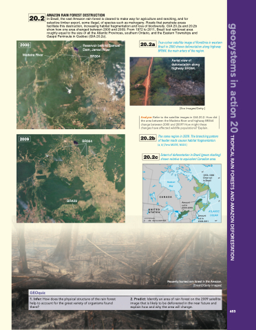
AMAZON RAIN FOREST DESTRUCTION
In Brazil, the vast Amazon rain forest is cleared to make way for agriculture and ranching, and for selective timber export, some illegal, of species such as mahogany. Roads that penetrate areas facilitate this destruction, increasing habitat fragmentation and loss of biodiversity. GIA 20.2a and 20.2b show how one area changed between 2000 and 2009. From 1972 to 2011, Brazil lost rainforest area roughly equal to the size of all the Atlantic Provinces, southern Ontario, and the Eastern Townships and Gaspé Peninsula in Québec (GIA 20.2c).
2009
BR364
Reservoir behind Samuel Dam, Jamari River
BR364
20.2a True-colour satellite image of Rondônia in western Brazil in 2000 shows deforestation along highway
BR364, the main artery of the region.
Aerial view of deforestation along highway BR364.
[Eco Images/Getty.]
Analyze: Refer to the satellite images in GIA 20.2. How did the area between the Madeira River and highway BR364 change between 2000 and 2009? How might these changes have affected wildlife populations? Explain.
20.2b The same region in 2009. The branching pattern of feeder roads causes habitat fragmentation.
(a, b) [Terra MODIS, NASA.]
20.2c Extent of deforestation in Brazil (green shading)
shown relative to equivalent Canadian area.
60°
45°
geosystems in action 20 TROPICAL RAIN FORESTS AND AMAZON DEFORESTATION
GEOquiz
BR429
Amount cut in 2000-2005
1. Infer: How does the physical structure of the rain forest help to account for the great variety of organisms found there?
2. Predict: Identify an area of rain forest on the 2009 satellite image that is likely to be deforested in the near future and explain how and why the area will change.
0
Amount
cut in
2006-2011 60°
(b) 2009
UNITED STATES
250 500 KILOMETRES
1972–1999
Clear cut 45° in Brazil
Hudson Bay
CANADA
Recently burned rain forest in the Amazon.
[Brasil2/Getty Images]
ATLANTIC OCEAN
653


