Page 703 - Geosystems An Introduction to Physical Geography 4th Canadian Edition
P. 703
 AQuantitativeSOlUTION Species Richness, Diversity, and Similarity
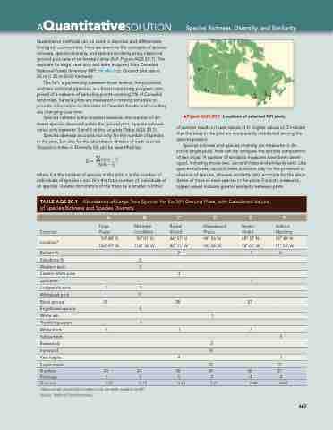
Quantitative methods can be used to describe and differentiate biological communities. Here we examine the concepts of species richness, species diversity, and species similarity using observed ground plot data at six forested sites (A–F, Figure AQS 20.1). The data are for large trees only and were acquired from Canada’s National Forest Inventory (NFI, nfi.nfis.org). Ground plot size is
25 m × 25 m (0.04 hectares).
The NFI, a partnership between three federal, ten provincial,
and two territorial agencies, is a forest monitoring program com- prised of a network of sampling points covering 1% of Canada’s land mass. Sample plots are measured a rotating schedule to provide information on the state of Canada’s forests and how they are changing over time.
Species richness is the simplest measure: the number of dif- ferent species observed within the ground plot. Species richness varies only between 3 and 6 at the six plots (Table AQS 20.1).
Species diversity accounts not only for the number of species in the plot, but also for the abundance of trees of each species. Simpson’s Index of Diversity (D) can be quantified by:
D = ank(nk -1) N(N - 1)
where k is the number of species in the plot, n is the number of individuals of species k and N is the total number of individuals of all species. Greater dominance of the trees by a smaller number
mFigure AQS 20.1 Locations of selected NFI plots.
of species results in lower values of D. Higher values of D indicate that the trees in the plot are more evenly distributed among the species present.
Species richness and species diversity are measures to de- scribe single plots. How can we compare the species composition of two plots? A number of similarity measures have been devel- oped, including shows two: Jaccard index and similarity ratio. Like species richness, Jaccard index accounts only for the presence or absence of species, whereas similarity ratio accounts for the abun- dance of trees of each species in the plots. For both measures, higher values indicate greater similarity between plots.
   A
B
C
D
E
F
Ecozone
Balsam fir Western larch Jack pine Whitebark pine Engelmann spruce Trembling aspen yellow birch Ironwood
Sugar maple
Taiga Plains
Montane Cordillera
2
11 4 1
Boreal Shield
2
Mixedwood Plains
Boreal Shield
Atlantic Maritime
 location*
  59° 48’ N
 50° 01’ N
 46° 51’ N
 44° 26’ N
 48° 37’ N
 45° 30’ N
124° 47’ W
 116° 18’ W
 82° 11’ W
 76° 08’ W
 78° 01’ W
 71° 03’ W
  1 6
 Subalpine fir
    5
          Eastern white pine
      3
       1
 lodgepole pine
  7
  1
          Black spruce
  29
    28
    27
    White ash
        1
      White birch
  5
    1
    7
    Basswood
        3
     *Approximate ground plot locations only are made available by NFI. Source: National Forest Inventory.
A
B
E
14 18
5
15
C
F
D
 TABLE AQS 20.1 Abundance of Large Tree Species for Six NFI Ground Plots, with Calculated Values of Species Richness and Species Diversity
 red maple
      4
      1
  Number
 41
 24
 38
 36
 36
 27
 richness
 3
 6
 5
 4
 4
 4
 Diversity
  0.47
  0.74
  0.45
  0.61
  0.40
  0.63
  667


