
Page 1 - Payne Soil Map_Neat
P. 1
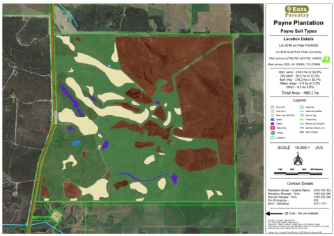
Payne Plantation
Payne Soil Types
Location Details
Lot 4296 on Plan P209300
Lot 4269 Scott River Road, Courtenay
Main access (UTM) 50H 6216106, 340629
Main access (DD) -34.183859, 115.270600
Wet sand - 244.4 ha or 50.9%
Dry sand - 54.3 ha or 11.3%
Rem Veg - 176.3 ha or 36.7%
Water areas - 0.9 ha or 0.2%
Other - 4.5 ha 0.9%
Total Area - 480.1 ha
Legend
Dry sand reserves
Wet sand watercourselines
Rem Veg (DPIRD) Native Veg
Water Powerlines
Other Rivers and streams
Total Area Surface Water Line
Water Shire Roads
Cadastre
SCALE 18,000:1 (A3)
Contact Details
Plantation Owner - Graeme Payne 0000 000 000
Plantation Manager - Ents 0429 920 288
Harvest Manager - Ents 0429 920 288
Fire Emergency - 000
Shire - Manjimup 9771 7777
QR Code - Not yet available
Projection: Universal Trans Mercator
Grid: EPSG 28350 GDA94 / MGA Zone 50
Source data: Bing VirtualEarth, Google Earth or Esri satellite imagery
This map was compiled using data believed to be correct at the time of printing.
Please doublecheck all critical data when in the field
Location Info - Universal Trans Mercator (UTM) & Decimal Degrees (DD)