
Page 34 - High Knob Master Plan
P. 34
7.
Coordinate with High Knob Communities: Ultimately, the wayfinding system would be coordinated by the HKRI in conjunction with the region’s localities. As mentioned previously in this section, this system was designed to strategically reflect the various hierarchy of identities (Communities -> Anchor Destinations -> Sub-Regions -> SWVA Region). It is an open source design that allows the localities to determine how the High Knob identity is incorporated into their signage. It is recommended that the technical committee coordinate with each community to advocate for the regional system, determine how the High Knob identity is used, and design individual signage based on the sign schedule above. Final sign designs must meet all MUTCD standards and be approved by VDOT.
8.
Establish Cost Estimates and Phasing Strategy: This report is a tool to guide the design of wayfinding signs as well as basic location selection and placement based on MUTCD standards. Upon the determination of sign locations and creation of a sign schedule:
» Based on total number and type of signage in sign schedule, estimate costs of the total wayfinding system.
»Identify potential local funding streams for wayfinding implementation - planning, design, fabrication, installation, maintenance.
9. Create Implementation Strategy for Fabrication and Installation: HKRI will need to engage a vendor to make specific material and location recommendations. It will be the responsibility of that contracted vendor to verify that all engineering drawings meet local, state, and federal guidelines and secure permits for each individual sign location.
» Create phased strategy for wayfinding implementation. Most wayfinding systems are implemented over multiple fiscal years. In High Knobs case, this phased strategy would likely be based on the individual communities and local funding.
» Implementation would include: Adoption of plan, coordination with VDOT, approval of management/maintenance policy, preparation of bid packages, RFQ/RFP, permitting, fabrication and installation.
» Depending on sign locations, jurisdictions, and phasing, intergovernmental agreements between the counties, towns, and city within the region may be necessary.
» Final permitting, fabrication and installation must be approved by VDOT based on MUTCD standards.
WAYFINDING MANAGEMENT
Wayfinding will be a key initiative of the HKRI. A primary method for planning and implementation would be to create a technical committee made up of representatives from HKRI, Friends of Southwest Virginia, communities, and partners (i.e., Spearhead Trails). That committee will be responsible for maintaining a current list of all destinations, destination mapping, determining sign location, managing the sign schedule, creating a phasing strategy, and securing financing for implementation and long-term maintenance.
Not less than 25’
Vehicular Directional
Not less than 25’
Vehicular Directional
Not less than 50’
Not less than 25’
Vehicular Directional
Not less than 50’
Vehicular Directional
Not less than 25’
Vehicular Directional
Not less than 25’
Vehicular Directional
Not less than 50’
34
CHAPTER 5: WAYFINDING
HIGH KNOB REGIONAL INITIATIVE
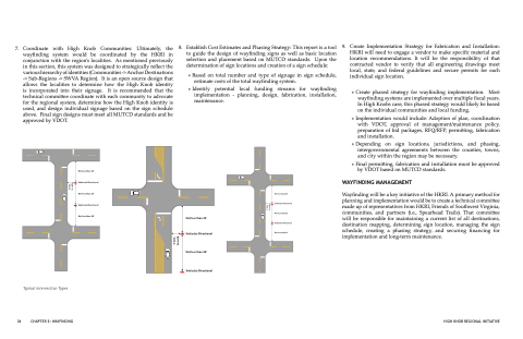
Typical Intersection Types
3’ min. to curb
3’ min. to curb
3’ min. to curb
