
Page 23 - Geologic Investigations in the Lake Valley Area, Sierra County, New Mexico
P. 23
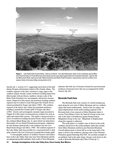
Apache Hill
U D
Monument Peak
LV
Figure 7.
rhyolite (pl. 1, section A-A′′), suggesting reactivation of the fault during Neogene deformation related to Rio Grande rifting. The southern segment of the fault, oriented at a large angle to the cauldron margin, bounds a major northwest-trending depression filled mainly with pre-Emory cauldron volcanic rocks of the Rubio Peak Formation (see aeromagnetic and gravity measure ments, Chapter B of this report); the northwest-trending southern segment may be related to early Paleogene Rio Grande rift tec tonism postulated by Seager and others (1984). The southern segment of the fault is also within the postulated northwest- trending Laramide Rio Grande uplift of Seager and others (1986). Gravity and aeromagnetic anomaly maps presented in Chapter B of this report reveal permissive evidence for such an uplift and related fault systems. This uplift is characterized by a series of northwest-trending basement blocks which extend into the southeast Black Range (fig. 2), upon which was deposited a thin mantle of Love Ranch Formation postorogenic conglomer ate that thickens dramatically to the northeast into the Love Ranch basin (Seager and others, 1986). The southern segment of the Lake Valley fault may possibly be a reactivated fault or fault splay related to the Late Cretaceous Laramide Rio Grande uplift.
A stereographic analysis of synthetic fractures and slicken lines in the Lake Valley fault zone near Town Mountain and the accompanying parallel antithetic fault south of Town Mountain
Lake Valley fault at Lake Valley. View to northeast. The Lake Valley fault, down on the southwest, places Mim bres Peak Formation of Town Mountain dome (where photo was taken) against Silurian Fusselman Dolomite. Apache Hill and Monument Peak, held up by Lake Valley Limestone and Rubio Peak Formation, respectively, mark the northern and eastern limits of the Lake Valley mining district (LV).
14 Geologic Investigations in the Lake Valley Area, Sierra County, New Mexico
indicates that both sets of fractures formed by near-horizontal northeast extensional stress that was accompanied by brittle fracture (fig. 8A).
Berrenda Fault Zone
The Berrenda fault zone consists of a north-trending seg ment along the west side of Sibley Mountain and two southern splays that trend southwesterly. North of the two splays, the major displacement on the north-trending segment of the Berrenda fault is best exposed at Sibley Mountain where it crosses Tierra Blanca Creek; the Santa Fe Group on the west side of the fault is downthrown against Pennsylvanian Magdalena Group on the east. Magnitude of displacement along this segment is unknown.
The north splay is a complex zone of down-to-the-north synthetic and down-to-the-south antithetic faults that extends from Sibley Mountain southwest past Berrenda Mountain. Overall displacement of about 600 m on the main fault of the splay is down to the northwest, placing rocks of the Thurman Formation against Kneeling Nun Tuff. An excellent example of an antithetic fault in the splay drops volcanic rocks down-to-the- south at Berrenda Mountain and O Bar O Peak (pl. 1).
