
Page 48 - Geologic Investigations in the Lake Valley Area, Sierra County, New Mexico
P. 48
33°00'
108°00'
107°30'
southeast-dipping Ordovician, Silurian, Devonian, and Missis sippian rocks exposed south of Berrenda Creek (pl. 1). The Ordovician El Paso and Montoya Groups and the Silurian Fus selman Dolomite underlie Quartzite Ridge, which is capped by a dip slope of silicified Fusselman. Devonian Percha Shale and landslide material that slid on the ductile Percha make up the strike valley southeast of Quartzite Ridge. Overlying the Percha Shale at Apache Hill, in ascending order, are the more resistant Mississippian Caballero Formation, the Lake Valley Limestone, small patches of Love Ranch Formation, and the oldest volcanic rocks in the study area. The ore-hosting Lake Valley Limestone makes up the dip slope of the ridge includ ing Apache Hill and adjacent low ridges.
The Lake Valley Limestone consists of four members in the map area: the Andrecito, the Alamogordo, the Nunn, and the Tierra Blanca (Chapter A). The lowermost Andrecito is slope- forming, thin-bedded, argillaceous limestone containing abun dant fenestelloid bryozoans and minor crinoid columnals. The overlying Alamogordo is ledge-forming, finely crystalline lime- stone, and the Nunn is slope-forming, marly, coarse-crystalline limestone with abundant crinoid fragments. The uppermost Tierra Blanca Member is ledge-forming, medium-bedded, and medium to coarsely crystalline limestone that contains abundant white to very light gray chert nodules and lenses.
In the district area, a thin remnant of Paleocene to Eocene Love Ranch Formation conglomerate, siltstone, and shale dis conformably overlies the Tierra Blanca Member of the Lake Valley Limestone. Conglomerate clasts are commonly Tierra Blanca chert, and therefore locally derived. At the top of Apache Hill, a silicified crinoid was observed as a clast in the conglomerate.
Eocene to Oligocene Rubio Peak Formation volcanic rocks lie unconformably on Love Ranch Formation and Lake Valley Limestone. In this area, the dark-colored volcanics consist of flows and flow breccias and include both hornblende- and pyroxene-bearing rocks. Rubio Peak volcanic rocks make up much of the topography south and east of the district. The Rubio Peak is only locally oxidized and (or) deuterically altered, and it is not ore bearing.
A thick rhyolite dike at the southwest edge of the Lake Val- ley district underlies a low hill between two strands of the Lake Valley fault (Chapter A, pl. 1). The rhyolite and related intru sion breccia are interpreted as part of the Town Mountain rhyo lite dome of Oligocene Mimbres Peak Formation that crops out southwest of the district and on the downthrown side of the Lake Valley fault. The rhyolite of the hill is characterized by delicate banding and vertical foliation, abundant altered pumice aligned along foliation, very fine grain size, a paucity of phenocrysts, and numerous lithic fragments. Lithic fragments include Kneel ing Nun Tuff, Rubio Peak Formation, and Proterozoic basement rocks. Brecciated Rubio Peak and Kneeling Nun occur along the edges of the rhyolite. A very fine grained rhyolite sill and associated veinlets cut the rhyolite. The lithic fragments, altered pumice fragments, sills, and breccia suggest explosive activity related to intrusion. Pieces of abandoned core drilled in brecci ated rhyolite along the Lake Valley fault just northwest of the district are barren of mineralized rock. The rhyolite is not min eralized except for minor manganese-oxide veinlets and pock ets. (See Appendix, samples Lake 62, 63.)
Taylor Creek Chloride
Cuchillo
Kingston Carpenter
Hermosa
Hillsboro
Tierra Blanca
Lake Valley Macho
Georgetown
NEW MEXICO
33°30'
0 0
10
20
30 KILOMETERS 20 MILES
EXPLANATION
Rhyolite-hosted tin deposits
10
Volcanic-epithermal vein deposits
Volcanic-epithermal vein and carbonate-hosted Pb-Zn-Ag deposits
Carbonate-hosted Ag-Mn and Pb-Zn deposits
Laramide vein, porphyry copper, skarn,
and carbonate-hosted Pb-Sn-Ag deposits
Emory cauldron boundary
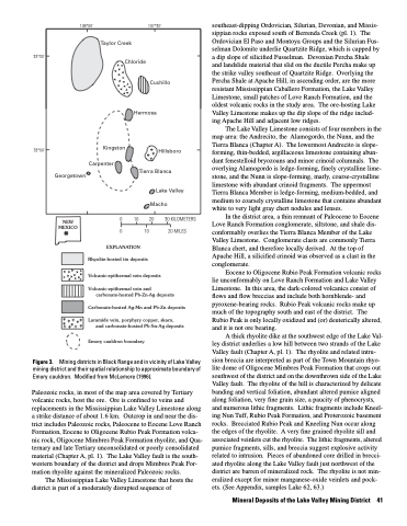
Mining districts in Black Range and in vicinity of Lake Valley mining district and their spatial relationship to approximate boundary of Emory cauldron. Modified from McLemore (1996).
Paleozoic rocks, in most of the map area covered by Tertiary volcanic rocks, host the ore. Ore is confined to veins and replacements in the Mississippian Lake Valley Limestone along a strike distance of about 1.6 km. Outcrop in and near the dis trict includes Paleozoic rocks, Paleocene to Eocene Love Ranch Formation, Eocene to Oligocene Rubio Peak Formation volca nic rock, Oligocene Mimbres Peak Formation rhyolite, and Qua- ternary and late Tertiary unconsolidated or poorly consolidated material (Chapter A, pl. 1). The Lake Valley fault is the south- western boundary of the district and drops Mimbres Peak For mation rhyolite against the mineralized Paleozoic rocks.
The Mississippian Lake Valley Limestone that hosts the district is part of a moderately disrupted sequence of
Figure 3.
Mineral Deposits of the Lake Valley Mining District 41
