
Page 55 - Geologic Investigations in the Lake Valley Area, Sierra County, New Mexico
P. 55
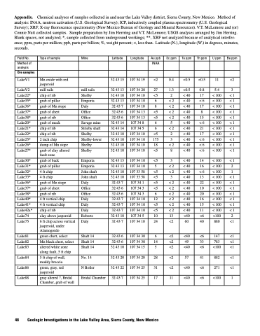
Appendix. Chemical analyses of samples collected in and near the Lake Valley district, Sierra County, New Mexico. Method of analysis: INAA, neutron activation (U.S. Geological Survey); ICP, inductively coupled plasma spectrometry (U.S. Geological Survey); XRF, X-ray fluorescence spectrometry (New Mexico Bureau of Geology and Mineral Resources). V.T. McLemore and (or) Connie Nutt collected samples. Sample preparation by Jim Herrring and V.T. McLemore; USGS analyses arranged by Jim Herring. Blank spaces, not analyzed; *, sample collected from underground workings; **, XRF not analyzed because of analytical interfer ence; ppm, parts per million; ppb, parts per billion; %, weight percent; <, less than. Latitude (N.), longitude (W.) in degrees, minutes, seconds.
Field No.
Type of sample
Mine
Latitude
Longitude
Au ppb
Sc ppm
Tappm
Th ppm
U ppm
Be ppm
Method of analysis
INAA
Ore samples
LakeV1
Mn oxide with red jasperoid
32 43 15
107 34 19
<2
0.4
<0.5
<0.5
11
<2
LakeV2
mill tails
mill tails
32 43 13
107 34 20
27
1.3
<0.5
0.8
5.4
3
Lake22*
chip of rib
Shelby
32 43 10
107 34 10
<5
2
< 40
17
< 100
<1
Lake35*
grab of pillar
Emporia
32 43 13
107 34 10
6
<2
< 40
<6
< 100
<1
Lake36*
grab of Mn stope
Daly
32 43 7
107 34 10
8
<2
< 40
17
< 100
<1
Lake37*
grab of chert
Office
32 43 6
107 34 13
<5
<2
< 40
8
< 100
<1
Lake38*
grab of rib
Office
32 43 6
107 34 13
<5
<2
< 40
15
< 100
<1
Lake20*
grab of muck
Savage mine
32 43 14
107 34 8
6
5
< 40
<6
< 100
<1
Lake21*
chip of rib
Strieby shaft
32 43 14
107 34 5
6
<2
< 40
21
< 100
<1
Lake22*
chip of rib
Shelby
32 43 10
107 34 10
<5
2
< 40
17
< 100
<1
Lake25*
2 inch chip
Shelby-lower
32 43 10
107 34 10
175
3
< 40
<6
< 100
<1
Lake26*
dump of Mn stope
Shelby
32 43 10
107 34 10
18
<2
< 40
<6
< 100
<1
Lake27*
grab of clay altered fault zone
Shelby
32 43 10
107 34 10
<5
8
< 40
<6
< 100
<1
Lake30*
grab of back
Emporia
32 43 13
107 34 10
<5
3
< 40
14
< 100
<1
Lake31*
grab of pillar
Emporia
32 43 13
107 34 10
5
<2
< 40
16
< 100
2
Lake32*
4 ft chip
John shaft
32 43 10
107 33 58
<5
<2
< 40
<6
< 100
1
Lake33*
4 ft chip
John shaft
32 43 10
107 33 58
<5
3
< 40
13
< 100
<1
Lake36*
grab of Mn stope
Daly
32 43 7
107 34 1
<5
<2
< 40
22
< 100
<1
Lake37*
grab of chert
Office
32 43 6
107 34 3
<5
<2
< 40
10
< 100
<1
Lake38*
grab of rib
Office
32 43 6
107 34 3
6
<2
< 40
20
< 100
<1
Lake40*
4 ft vertical chip
Daly
32 43 7
107 34 10
12
<2
< 40
16
< 100
<1
Lake41*
4 ft vertical chip
Daly
32 43 7
107 34 10
<5
<2
< 40
15
< 100
<1
Lake42a*
chip of rib
Daly
32 43 7
107 34 10
<5
<2
< 40
11
< 100
<1
Lake74
clay above jasperoid
Roberts
32 43 10
107 34 5
10
13
<40
<6
<100
2
Lake75
6 ft chip across vertical jasperoid, under Alamogordo
Daly
32 43 7
107 34 10
24
<2
60
40
880
<1
Lake81
green chert, select
Shaft 14
32 43 6
107 34 30
6
<2
<40
<6
147
<1
Lake82
Mn black chert, select
Shaft 14
32 43 6
107 34 30
14
<2
49
33
783
<1
Lake83
altered white zone along fault, 5 ft chip
Shaft 14
32 43 10
107 34 15
5
<2
<40
<6
<100
<1
Lake84
5 ft chip of wall, muddy breccia
No. 14
32 43 20
107 34 20
28
<2
57
41
882
<1
Lake86
green, gray, red jasperoid
N Boiler
32 43 22
107 34 25
31
<2
<40
<6
271
<1
Lake88
gray altered ?, Bridal Chamber, grab of wall
Bridal Chamber
32 43 7
107 34 25
17
11
<40
<6
<100
1
48 Geologic Investigations in the Lake Valley Area, Sierra County, New Mexico
