
Page 2 - Ranger Demo
P. 2
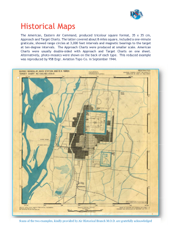
Historical Maps
The American, Eastern Air Command, produced tricolour square format, 35 x 35 cm, Approach and Target Charts. The latter covered about 8 miles square, included a one-minute graticule, showed range circles at 3,000 feet intervals and magnetic bearings to the target at ten-degree intervals. The Approach Charts were produced at smaller scale. American Charts were usually double-sided with Approach and Target Charts on one sheet. Alternatively, photo-mosaics were shown on the back of each type. This reduced example was reproduced by 958 Engr. Aviation Topo Co. in September 1944.
Scans of the two examples, kindly provided by Air Historical Branch M.O.D. are gratefully acknowledged
