
Page 52 - Ranger Demo
P. 52
The Senegambian Connection Smallest African Country
Alan Milne and Robin Waters
The Gambia is a narrow flat strip of land 10 miles either side of the Gambia river and 200 miles long. The source of the river is in Guinea, 500 bendy river miles from its wide estuary on the Atlantic coast. This country is the smallest independent country on the mainland of Africa. The Anglo-French treaty defining its boundaries dates from 1889, and it took another 15 years to demarcate. Until 2019 there was no bridge across the river for the whole length of the country! It is surrounded by Senegal except for a relatively short Atlantic coast and has an economy based on farming, fishing and tourism. Groundnuts are the main crop. The highest point in the Gambia is only 53 m above sea level. On either side of the river, the country is generally reasonably open savanna, but along several tributaries is heavily wooded.
Boundary disputes
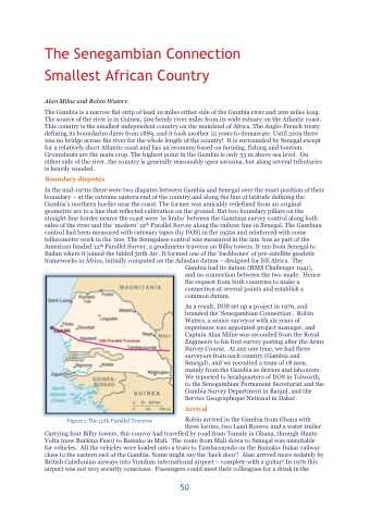
In the mid-1970s there were two disputes between Gambia and Senegal over the exact position of their boundary – at the extreme eastern end of the country and along the line of latitude defining the Gambia’s northern border near the coast. The former was amicably redefined from an original geometric arc to a line that reflected cultivation on the ground. But two boundary pillars on the straight-line border nearer the coast were ‘in limbo’ between the Gambian survey control along both sides of the river and the ‘modern’ 12th Parallel Survey along the railway line in Senegal. The Gambian control had been measured with catenary tapes (by DOS) in the 1950s and reinforced with some tellurometer work in the ‘60s. The Senegalese control was measured in the late ‘60s as part of the American funded 12th Parallel Survey, a geodimeter traverse on Bilby towers. It ran from Senegal to Sudan where it joined the fabled 30th Arc. It formed one of the ‘backbones’ of pre-satellite geodetic frameworks in Africa, initially computed on the Adindan datum – designed for NE Africa. The
Figure 1 The 12th Parallel Traverse
Gambia had its datum (HMS Challenger 1941), and no connection between the two made. Hence the request from both countries to make a connection at several points and establish a common datum.
As a result, DOS set up a project in 1976, and branded the ‘Senegambian Connection’. Robin Waters, a senior surveyor with six years of experience was appointed project manager, and Captain Alan Milne was seconded from the Royal Engineers to his first survey posting after the Army Survey Course. At any one time, we had three surveyors from each country (Gambia and Senegal), and we recruited a team of 18 men, mainly from the Gambia as drivers and labourers. We reported to headquarters of DOS in Tolworth, to the Senegambian Permanent Secretariat and the Gambia Survey Department in Banjul, and the Service Geographique National in Dakar.
Arrival
Robin arrived in the Gambia from Ghana with
three lorries, two Land Rovers, and a water trailer. Carrying four Bilby towers, this convoy had travelled by road from Tamale in Ghana, through Haute
Volta (now Burkina Faso) to Bamako in Mali. The route from Mali down to Senegal was unsuitable for vehicles. All the vehicles were loaded onto a train to Tambacounda on the Bamako-Dakar railway close to the eastern end of the Gambia. Some might say the ‘back door’! Alan arrived more sedately by British Caledonian airways into Yundum international airport – complete with a guitar! In 1976 this airport was not very security conscious. Passengers could meet their colleagues for a drink in the
50
