
Page 4 - Catch_Return24_25
P. 4
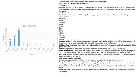
Absolutely! Let's analyze the data presented in the chart and create a report.
Report: Fish Catch Analysis at High Coniscliffe
Introduction:
This report analyzes the fish catch data for High Coniscliffe, focusing on the types of fish caught and the total number of
visits. The data is presented in a bar chart format, allowing for a clear visual comparison of the different fish species and
visit counts.
Data Presentation:
The chart displays the number of fish caught for each species, as well as the total number of visits. The fish species
represented are:
•Total Visits
•Trout
•Grayling
•Barbel
•Chub
•Dace
•Pike
•Roach
•Bream
•Sea Trout
•Gudgeon
Analysis:
Dominant Species: Grayling is the most abundant fish species caught, with a significant count of 751. This is considerably
higher than any other species, indicating that Grayling is the dominant fish in this location.
Significant Trout Population: Trout also shows a substantial catch number of 404, suggesting a healthy population of this
species in the area.
Moderate Populations: Chubb and Gudgeon have moderate catch numbers, with 57 and 53 respectively.
Lower Catch Numbers: Barbel, Dace, Pike, Roach, Bream, and Sea Trout have relatively low catch numbers, ranging from
1 to 22. This suggests either lower populations of these species or that they are less frequently targeted by anglers.
Total Visits: The total number of visits is 243. This provides context for the catch numbers, indicating the overall level of
angling activity at High Coniscliffe.
Observations and Interpretations:
The data suggests that High Coniscliffe is a popular location for anglers targeting Grayling and Trout.
The significant difference in catch numbers between Grayling/Trout and other species could be due to several factors,
including species population size, angler preference, or fishing methods used.
The relatively low number of visits compared to the high Grayling catch might suggest a high catch rate per visit for this
species.
The presence of Sea Trout, albeit in low numbers, indicates that the location is connected to a waterway that supports
migratory fish.
