
Page 10 - UGU Dstrct Mun IDP Report '21-22
P. 10
Chapter 1: Executive Summary
In compliance with the Local Government Municipal Systems Act, 32 of 2000, the Ugu District Council adopted a reviewed Integrated Development Plan in June 2020 which is the year being implemented. The process has been initiated for the last review of the 2017/18 – 2021/22 IDP. This plan aims at providing a basis for both public and private sector investment in the district and strengthen intergovernmental relations within the spheres of government.
1.1 Who Are We?
Ugu District Municipality is a category C municipality which is a municipality that has municipal executive and legislative authority in an area that includes more than one municipality. It is 4 908 km2 in extent and boasts a spectacular coastline of 112 kilometres, which forms its Eastern border. The region is bordered on the North by the eThekwini, in the West by Umgungundlovu and Harry Gwala District municipalities and on the Southern side shares its borders with the Eastern Cape Province. The municipality consists of 85 municipal wards, which culminate into four local municipalities, namely Ray Nkonyeni, Umuziwabantu, Umzumbe and Umdoni. Ugu District municipality has forty (40) traditional council areas within its jurisdictional area and these are:
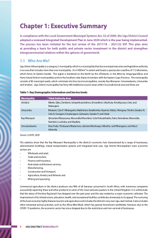
Table 1: Key Demographic Information and Service levels
Municipality
Tribal Authority Area
Umdoni
Mbele; Qiko; Zembeni; Izimpethuzendlovu; Emandleni; Ukuthula; AmaNyuswa; Cele; and Malangeni.
Umzumbe
Bhekani; Cele P; Nhlangwini; Mabheleni; KwaBombo; Nyavini; Ndelu; Hlongwa; Thulini; Qwabe N; Cele K; Dungeni; Emadungeni; Qoloqolo; Qwabe P; and Hlubi.
Ray Nkonyeni
Qiniselani/Manyuswa; Mavundla/Nkumbini; Cele/Vukuzithathe; Xolo; Nzimakwe; Mavundla; Nsimbini; Lushaba; and Madlala.
Umuziwabantu
Kwa-Fodo; Thokozani/Madumisa; Jabulani/Beshwayo; Mbotho; Jali/Nhlangano; and Maci/ Isibonda.
Source: CoGTA, 2020
The statistics show that the Ray Nkonyeni Municipality is the district’s economic hub characterised by a range of businesses, administrative buildings, mixed transportation systems and integrated land uses. Ugu District Municipality’s main economic sectors are:
• Wholesale and retail,
• Trade and tourism,
• Finance and Insurance,
• Real estate and Business services,
• Manufacturing,
• Construction and Transport,
• Agriculture, forestry and fisheries and
• Mining and quarrying.
Commercial agriculture in the district produces one-fifth of all bananas consumed in South Africa, with numerous companies successfully exporting these and other products to some of the most exclusive packers in the United Kingdom. It is unfortunate that the status of the blue flag beach has dropped over the past years and this was marked as a major economic cultivator. The improvement of its infrastructure, education, health, and recreational facilities contributes immensely to its appeal. The nurturing of the local economy highly features tourism and agriculture and includes the district’s very own Ugu Jazz Festival. It also includes other renowned annual activities, such as the Africa Bike Week, which has gained momentum worldwide. However, due to the COVID 19 pandemic, the economic sector has since dropped due to the restrictions and non-survival of businesses.
8 UGU DISCTRICT MUNICIPALITY
