
Page 115 - UGU Dstrct Mun IDP Report '21-22
P. 115
3.5.11.2 Intermodal Public Transport Facilities
The KwaZulu-Natal Department of Transport (KZNDoT) has identified the development of intermodal public transport facilities as one of the key public transport improvement elements. An intermodal facility is a focal point where many modes of transportation converge to provide economical and efficient service to destinations. Port Shepstone has been identified as a potential nodal point for building such a facility. This suggests that there is a constant demand for transport feeding from the more rural areas into this economic hub.
3.5.11.3 Freight Rail Infrastructure
The main rail corridor in the district is the standard gauge South Coast line that runs from Port Shepstone to eThekwini. The volume of freight has been reduced over time due to more goods moving to the N2 for transportation. The main commodity on the rail network is 500,000 tons of lime clinker from Simuma to Mount Vernon. There are no longer any passenger services in operation on this line. A narrow-gauge line used to operate between Port Shepstone and Harding. This was primarily used to transport timber and sugar cane. The line was also used for tourism, providing excursions to Paddock. Unfortunately, the line has been abandoned due to the demise of the Alfred County Railway and the final destruction of the Izotsha river bridge in 2007.
There is definitely a need for revival of passenger rail and additional freight rail capacity within the district has been highlighted during the GDS consultation process. The standard gauge line is supplemented by a narrow-gauge line from Port Shepstone to Harding, which no longer functions and is in a state of disrepair. This is primarily used to transport timber and sugar cane. Overall, the volume of freight on this line has reduced and more goods are being transported by road along the N2. The reason given for this switch is that many branch lines are no longer in operation. An opportunity for the district is that Transnet has recently released a plan to invest R300bn in infrastructure within the country, of which R151 billion has been earmarked for freight rail.
Further investigation into demand should be undertaken to inform an approach to Transnet. This could include a review of the current location of the railway line with a proposal to re-route the railway line away from the coast into the hinterland. This would serve to boost tourism along the coastal strip and economic activity within the hinterland 3.10.4.3 Roads and Transport. The road hierarchy in the district starts with national roads, then provincial roads down to local municipal roads. The N2 runs parallel to the coast with plans to extend this coastal route into the Eastern Cape. The provincial road network provides a high proportion of the road network in Ugu and covers a vast range of types of roads from main regional links (class 2) through to local roads (class 7). In terms of road usage, up to date traffic volume data is only available for the N2 and R103.
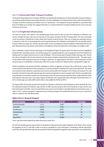
The largest traffic volumes pass along the N2 towards Port Shepstone, and further towards Kokstad, as well as along the R61 from Port Shepstone towards Port Edward. Large volumes of traffic also pass along the R612 from Park Rynie to Ixopo and the road from Umtentweni to St Faiths. Access to road infrastructure varies across the district, especially between rural and urban areas. In Table 3.10.4.3.1, access to transport is measured in terms of the percentage of households that have access to Level 1 and Level 3 roads (i.e. national, main and district roads).
Table 3.10.4.3.1: Access to Transport
Source: Ugu District Municipality Sector Wide Infrastructure Audit, 2014
The SDF has identified priority road corridors for development that will promote spatial integration of the district. These include the upgrading of the P77 and P58 in order to increase accessibility for rural communities. Consultations with the agricultural sector have also identified key roads and causeways that need to be targeted for upgrade to open up areas for commercial activity.
Local Municipality
HH within 1 km of Road
Total HH
Percentage
Former Vulamehlo
11,771
15,661
75
Umzumbe
24,274
31,801
76
Ray Nkonyeni
56,989
60,521
87
Umuziwabantu
17,956
20,840
86
Umdoni
16,452
17,257
95
Ugu District
127,442
146,080
87
IDP REVIEW 113
