
Page 194 - UGU Dstrct Mun IDP Report '21-22
P. 194
features there is scope for the establishment of different types of tourism routes through the area including landscape, hiking, mountain biking and culture. This in turn would enable involvement of local communities in the guiding and hospitality industry. In the rural areas of the District where the emphasis is on sustaining agriculture and open space, adjustments will also have to be introduced into the traditional system of land allocation and municipal system of land use. This will involve defining limits to settlement expansion and internal sub-division of land. It will also need to involve including controls over use of agricultural land and open space such that it cannot be converted into further housing development.
5.1.3 Spatial Reconstruction of the Municipality
The spatial reconstruction of the municipality follows an understanding of the character of the District in terms of the physical, social and economic environment. This is followed by an understanding of the systems and/or guidelines to be used in bridging the gap between current spatial realities and the spatial objectives of the SDF. Central to the systems and/or guidelines for SDF development are SPLUMA principles and objectives which have been discussed and related guidelines or interventions such as planning having taken into account nodes, corridors and other structuring and restructuring elements.
The first structuring element is the development and reinforcement of a system of varied activity nodes. This will enable greater access to districtwide opportunities, as well as equitable access to a system of local opportunities. The idea is to ensure that all people within the area live within easy walking distance of a public transport hub which will link to the district’s public transport systems. These nodes, depending on their position in the hierarchy, will form points of access to a range of local and in some cases, regional opportunities. Through the focus of development at these points the ‘emerging core’ will begin to reflect the opportunities that are present in the more developed areas of the Ugu District Municipality.
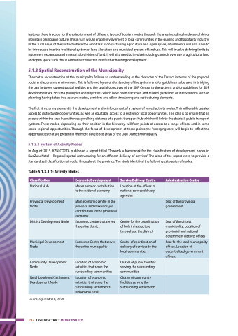
5.1.3.1 System of Activity Nodes
In August 2015, KZN COGTA published a report titled “Towards a framework for the classification of development nodes in KwaZulu-Natal – Regional spatial restructuring for an efficient delivery of services” The aims of the report were to provide a standardised classification of nodes throughout the province. The study identified the following categories of nodes:
Table 5.1.3.1.1: Activity Nodes
Classification
Economic Development
Service Delivery Centre
Administration Centre
National Hub
Makes a major contribution to the national economy
Location of the offices of national service delivery agencies
Provincial Development Node
Main economic centre in the province and makes major contribution to the provincial economy
Seat of the provincial government
District Development Node
Economic centre that serves the entire district
Centre for the coordination of bulk infrastructure throughout the district
Seat of the district municipality. Location of provincial and national government districts offices
Municipal Development Node
Economic Centre that serves the entire municipality
Centre of coordination of delivery of services to the local communities
Seat for the local municipality offices. Location of decentralised government offices.
Community Development Node
Location of economic activities that serve the surrounding communities
Cluster of public facilities serving the surrounding communities
Neighbourhood/Settlement Development Node
Location of economic activities that serve the surrounding settlements (urban and rural)
Cluster of community facilities serving the surrounding settlements
Source: Ugu DM SDF, 2020
192 UGU DISCTRICT MUNICIPALITY
