
Page 36 - UGU Dstrct Mun IDP Report '21-22
P. 36
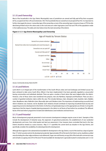
 3.1.5 Land Ownership
Most of the households in the Ugu District Municipality’s area of jurisdiction are owned and fully paid off by their occupants (61%), occupied rent free is 9% and rented also 16%. The households that are owned but not yet paid off are 9%. It is important to further interrogate the tenure / ownership type of the ownership as most of the ownership type is long term lease or PTO the title deed being limited only to the urban areas as the rural areas are under Ingonyama Land Trust and 79% of the population reside in the traditional areas. The table and chart below show the land ownership of the district.
Figure 3.1.5.1: Ugu District Municipality Land Ownership
Source: Community Survey Stats SA 2016
3.1.6 Land Reform
Land reform is an integral part of the transformation of the South African urban and rural landscape and limited success has been achieved to date across South Africa. Where it has been implemented it has been generally regarded as unsuccessful leaving communities and individuals destitute. There are quite a number of land claims that were lodged within the district. However, a few of these claims were transferred into projects, inter alia Nzimkwe, Impenjati and Khoshwani. There are also a number of gazetted restitution claims within the area. This includes Beshawu claim, Ezinqoleni claim, kwaXolo claim, Madlala claim, Masakhane claim, Mathulini claim, Mavundla claim and Oshabeni claim. The importance of implementing successful land reform initiatives can, however, not be doubted. Such initiatives should contribute to improving household food security and supporting economic development in the District. As the focus of spatial planning is on the appropriate use of land, it is of specific importance that the impact of spatial planning proposals in the district on all facets of land reform be considered. The different facets of the land reform programme include land redistribution; land restitution and land tenure.
3.1.7 Land Potential
Much of development proposals presented in local economic development strategies require access to land. Examples of this include the development of industrial areas, the expansion of agricultural production, the establishment of new residential developments and more. From initial spatial and land use assessment, it has, however, been concluded that land in the Ugu District should be viewed as a scarce resource. Map 3.1.7.1 quantifies the current land use situation in the Ugu District, and specifically considers the availability of undeveloped land for development.
Although there appears to be substantial land available for development in the Ugu District, much of this land has a slope of greater than 13o which severely restricts the development potential. Approximately 30% of the land in the District can be classified as settled areas (including the urban edge and dense rural settlement). Sugar cane and forestry occupy 20% of the land with commercial crops and orchards occupying only 0.5% of the land. The land available for development is generally located in small pockets and / or not
 34 UGU DISCTRICT MUNICIPALITY
