
Page 46 - UGU Dstrct Mun IDP Report '21-22
P. 46
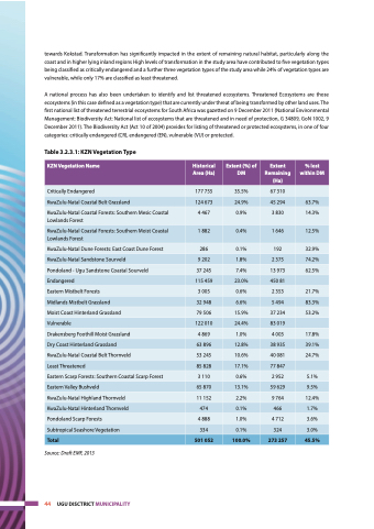
 towards Kokstad. Transformation has significantly impacted in the extent of remaining natural habitat, particularly along the coast and in higher lying inland regions High levels of transformation in the study area have contributed to five vegetation types being classified as critically endangered and a further three vegetation types of the study area while 24% of vegetation types are vulnerable, while only 17% are classified as least threatened.
A national process has also been undertaken to identify and list threatened ecosystems. Threatened Ecosystems are those ecosystems (in this case defined as a vegetation type) that are currently under threat of being transformed by other land uses. The first national list of threatened terrestrial ecosystems for South Africa was gazetted on 9 December 2011 (National Environmental Management: Biodiversity Act: National list of ecosystems that are threatened and in need of protection, G 34809, GoN 1002, 9 December 2011). The Biodiversity Act (Act 10 of 2004) provides for listing of threatened or protected ecosystems, in one of four categories: critically endangered (CR), endangered (EN), vulnerable (VU) or protected.
Table 3.2.3.1: KZN Vegetation Type
 KZN Vegetation Name
 Historical Area (Ha)
 Extent (%) of DM
 Extent Remaining (Ha)
 % lost within DM
 Critically Endangered
  177 755
  35.5%
  67 310
   KwaZulu-Natal Coastal Belt Grassland
 124 673
 24.9%
 45 294
 63.7%
 KwaZulu-Natal Coastal Forests: Southern Mesic Coastal Lowlands Forest
4 467
0.9%
3 830
14.3%
 KwaZulu-Natal Coastal Forests: Southern Moist Coastal Lowlands Forest
 1 882
 0.4%
 1 646
 12.5%
 KwaZulu-Natal Dune Forests: East Coast Dune Forest
 286
 0.1%
 192
 32.9%
 KwaZulu-Natal Sandstone Sourveld
  9 202
  1.8%
  2 375
  74.2%
 Pondoland - Ugu Sandstone Coastal Sourveld
37 245
7.4%
13 973
62.5%
 Endangered
 115 459
 23.0%
 450 81
  Eastern Mistbelt Forests
 3 005
 0.6%
 2 353
 21.7%
 Midlands Mistbelt Grassland
  32 948
  6.6%
  5 494
  83.3%
 Moist Coast Hinterland Grassland
79 506
15.9%
37 234
53.2%
 Vulnerable
 122 010
 24.4%
 83 019
  Drakensberg Foothill Moist Grassland
 4 869
 1.0%
 4 003
 17.8%
 Dry Coast Hinterland Grassland
  63 896
  12.8%
  38 935
  39.1%
 KwaZulu-Natal Coastal Belt Thornveld
53 245
10.6%
40 081
24.7%
 Least Threatened
 85 828
 17.1%
 77 847
  Eastern Scarp Forests: Southern Coastal Scarp Forest
 3 110
 0.6%
 2 952
 5.1%
 Eastern Valley Bushveld
 65 870
 13.1%
 59 629
 9.5%
 KwaZulu-Natal Highland Thornveld
  11 152
  2.2%
  9 764
  12.4%
 KwaZulu-Natal Hinterland Thornveld
474
0.1%
466
1.7%
 Pondoland Scarp Forests
 4 888
 1.0%
 4 712
 3.6%
 Subtropical Seashore Vegetation
 334
 0.1%
 324
 3.0%
 Total
  501 052
  100.0%
  273 257
  45.5%
    Source: Draft EMF, 2013
44 UGU DISCTRICT MUNICIPALITY
