
Page 58 - UGU Dstrct Mun IDP Report '21-22
P. 58
The District Call Centre is equipped with a control centre system (Citi Call). The system allows activation of all primary responders in seconds upon receipt of an emergency. It has an integrated system that enables generation of summary of statics on all incidents reported, status of the incident and highlights available emergency relief stock and its GIS system caters for mapping of district fire hydrants for fire teams and mapping of all known hazards. The Ugu District has become prone to several disasters over the years. Because of climate change and changes in weather patterns, the following have become the main causes of the disasters being strong winds, heavy rains resulting in flash floods, lightning, storms, and drought which makes it imperative for the district to ensure that it prevents, mitigates by minimises impact, and further responds efficiently and effectively to these disasters.
3.3.14 DRM: Integrated Institutional Capacity
It is imperative that each municipal department and local municipality within the district assign a person or section within the department / local municipality to be the nodal point for disaster management activities in that department / local municipality. The same applies to national and provincial departments operating within the municipality. The disaster management activities to be performed within departments and local municipalities include participation in disaster risk reduction as well as preparedness and response. It is important to note that disaster management has a different structure which needs to operate in. Disaster Management in the Ugu District interfaces the local municipal and provincial spheres through the various forums.
This communication is coupled with decision making ability and ultimate responsibility and accountability present on three different and all very important levels which are:
• Strategic level;
• Tactical Level; and
• Operational Level.
3.3.15 Risk Assessment
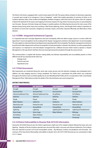
Risk Assessments are conducted during the sector plan review process and risk reduction strategies were developed and in addition, the risks mapping exercise is being completed. The District has a ward-based risk profile which was conducted throughout the District. Each Local Municipality has its own Ward Based Risk Profile which is incorporated in their Local Disaster Management Plans. Table below provides the details of the risk prioritised as per sector programme.
DISTRICT RISK PROFILE
UMDONI
RAY NKONYENI
UMUZIWABANTU
UMZUMBE
Drought
Drought
Drought
Drought
Structural Fires
Structural Fires
Structural Fires
Structural Fires
Informal Settlement Fires
Informal Settlement Fires
Air pollution
Air Pollution
Veld Fires
Veld Fires
Veld Fires
Veld fires
Floods
Floods
Floods
Floods
Water Pollution
Hailstorms
Hailstorms
Water Pollution
Hazmat by road
Hazmat by road
Hazmat by road
Hazmat by road
Strong Winds
Strong Winds
Strong Winds
Strong Winds
Lightning
Lightning
Lightning & Thunderstorms
Lightning & Thunderstorms
Storm Surge
Storm Surge
Water Pollution
Wild pigs
Air Pollution
Water Pollution
Storm surge
Drownings
Drownings
Drownings
3.3.16 District Vulnerability to Disaster Risk 2019/20 Information
During the 2019/2020 financial year, the District experienced a high level of fire related incidents followed by heavy rains and lightning. Majority of the fire incidents reported were structural fires within rural areas and informal settlements. The incidents that were reported occurred in all 4 local municipalities namely: - Ray Nkonyeni, Umdoni, Umuziwabantu and Umzumbe. The summary of the Ugu District Municipality vulnerability to disaster risk in the 2019/ 2020 financial year are summarised in table 3.3.2.1.1 below.
56 UGU DISCTRICT MUNICIPALITY
