
Page 10 - Aerotech News and Review, Jan. 5 2018
P. 10
High Desert Hangar Stories
Hills, poppies, planes: A home for airport bums
by Bob Alvis
special to Aerotech News
After being approved by the Re- gional Planning Commission of Los Angeles County the airport opened
if they could use the name Quartz Hill for the whole neighborhood and, as the airport comprised 80 acres, it also helped established the community!
Pike and Hoak never expected the airport to be public or grow so big but once it was opened, their friends kept asking for flying lessons. Lloyd said that the reason the airport flourished was because professionals in the field of construction wanted to work in ex- change for flight time! The first build- ing to be built was the flight office, and the second the restrooms and, and the last the hanger and the gas island.
Laura Pike, Lloyds wife, ran the flight office — she said she preferred the ground, even though she did learn to fly. It’s amazing to think that over the years that Pike and Hoak ran the airport, they turned out in the neigh- borhood of 400 to 500 pilots — both men and women!
One of those students would be- come responsible for the documenta- tion of a growing Antelope Valley. When the late Frank Stubbings of Stubbings Studio took his first flying lesson from Lloyd in 1951, it was the start of his collection of more than 20,000 aerial photos of the Antelope Valley. Once Frank got his license and his own plane he would go up alone with a camera on a stick between his legs and photograph everything in sight. He figured that sometimes he would make 25 or 30 landings a day!
Pike and his wife, along with Hoak, owned and operated the airport from 1946 until 1964 when they leased the airport to Elsworth Ritter. Later, Will Banks operated the airport, and, in 1968, Norm Sonberg and Mike Hinn took over operations.
In 1968, a friend of mine named Doc Burch bought the airport. Also a country and western performer, he owned and operated it for 20 years.
The year was 1946 and two broth- to the public and on March 10, 1946, ers-in-law found themselves at a cross people came from all over the Valley roads. to take opening day scenic passenger
Both war time instructors from flights and join in the celebration of War Eagle Field/Polaris Flight Acad- the newly opened airport.
emy here in Lancaster, it was going to be hard for them to walk away from the Valley that they had flown over hundreds of times as they instructed young men to fly for the United States Army Air Corps.
Lloyd Pike and F.A. Hoak made numerous flights over the Valley, and, in a location known as Earls Station, they spotted the area that would be- come a landmark for many years in the Antelope Valley.
With a southwest wind and a hill to the south, a field covered with weeds most of the year and poppies in the spring time became the focus of their attention. They wanted to open an air- port and this was the spot they wanted to make it happen.
One thing that was required by the FAA before it opened, was that the airport need a name, and a representa- tive stopped by asking for an official name. Earls Station or P&H Flying Service just didn’t work for various reasons and the FAA representative asked them if the big hill that bor- dered their property had a name. Why, that’s called Quartz Hill, so named for its high content of quartz mineral rocks that spread across it. Within weeks the name Quartz Hill Airport was on aeronautical maps nationally and worldwide!
Today the area and town known as Quartz Hill owes its identity to the air- port. I wasn’t long before the commu- nity officials from Earls Station asked
Courtesy photograph Quartz Hill Airport in the late 1940s early 1950s looking towards the south west.
Where airport bums could always be found — This 1956 photograph of the fuel pump island at Quartz Hill Airport, complete with a collection of planes that would warm the hearts of many wing nuts!
Courtesy photograph Quartz Hill Airport in the 1970s looking northwest towards a field of poppies.
Courtesy photograph
Those years and that history I will share in the next issue, for his time at Quartz Hill Airport is a story all
in itself!
To be continued, but for now, Bob
out ...
Prototype space sensors take test ride on NASA ER-2
Scientists recently completed test flights with prototypes of potential satellite sen- sors over the Western United States, probing basic science questions about aerosols, clouds, air quality and global ocean ecosystems.
The flight campaign, called Aerosol Characterization from Polarimeter and Lidar, sought to test capabilities of several proposed instruments for the Aerosol-Cloud- Ecosystem pre-formulation study.
Aerosols are small solid or liquid particles suspended in the Earth’s atmosphere, like fine dust, smoke, pollen or soot. These particles scatter and absorb sunlight and are critical to the formation of clouds and precipitation. Scientists can analyze this scattered light using instruments like polarimeters, which measure the color and po- larization of the scattered light, and lidars, which use lasers to probe the atmosphere. Together these data sets provide key information about aerosol properties including size, shape and chemical composition—information which provides better under- standing and assessment of their effects on weather, climate and air quality.
Prior to being launched into space, airborne versions of satellite sensors typically take a test ride on NASA’s ER-2 high altitude aircraft. The platform, based at NASA’s Armstrong Flight Research Center in Palmdale, Calif., flies at altitudes of up to 70,000 feet, and provides a vantage point and conditions similar to space. By flying these instruments on an aircraft before the expense of launching them into space, scientists and engineers can make adjustments to the hardware and data retrieval algorithms.
The ER-2 also enables scientists to observe specific events of interest like wildfires
See ER-2, Page 12
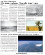
NASA photograph by Stu Broce
The view from NASA’s ER-2 flying at approximately 65,000 feet near a controlled fire burning near Flagstaff, Ariz., during the Aerosol Characterization from Polarimeter and Lidar (ACEPOL) airborne campaign on Nov. 7.
10 Aerotech News and Review January 5, 2018 www.aerotechnews.com ........ facebook.com/aerotechnewsandreview
