
Page 105 - Green - Maritime Archaeology: A Technical Handbook. 2nd ed
P. 105
84 Maritime Archaeology: A Technical Handbook, Second Edition
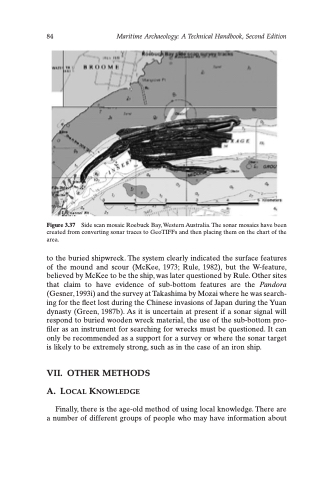
Figure 3.37 Side scan mosaic Roebuck Bay, Western Australia. The sonar mosaics have been created from converting sonar traces to GeoTIFFs and then placing them on the chart of the area.
to the buried shipwreck. The system clearly indicated the surface features of the mound and scour (McKee, 1973; Rule, 1982), but the W-feature, believed by McKee to be the ship, was later questioned by Rule. Other sites that claim to have evidence of sub-bottom features are the Pandora (Gesner, 1993i) and the survey at Takashima by Mozai where he was search- ing for the fleet lost during the Chinese invasions of Japan during the Yuan dynasty (Green, 1987b). As it is uncertain at present if a sonar signal will respond to buried wooden wreck material, the use of the sub-bottom pro- filer as an instrument for searching for wrecks must be questioned. It can only be recommended as a support for a survey or where the sonar target is likely to be extremely strong, such as in the case of an iron ship.
VII. OTHER METHODS A. LOCAL KNOWLEDGE
Finally, there is the age-old method of using local knowledge. There are a number of different groups of people who may have information about
