
Page 77 - Green - Maritime Archaeology: A Technical Handbook. 2nd ed
P. 77
56 Maritime Archaeology: A Technical Handbook, Second Edition
although it is extremely difficult to handle and needs to be used with caution as it has a high breaking strain and it is not easy to cut.
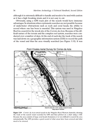
Obviously, using a GPS track plot of the search would have immense advantages. In situations where systematic searches are not possible because of underwater obstructions such as reefs and coral heads, the ability to record where one has been is essential. This system was used in Ningaloo Reef in a search for the wreck site of the Correio da Azia. Because of the dif- ficult nature of the terrain and the complex reef system, searches were con- ducted over a number of days. At the end of each day the track of the search was laid down on a geographic information system (GIS) to record the path of the vessel and thus the area visually searched (see Figure 3.19). It was
Figure 3.19 Correio da Azia towed search in the Ningaloo Reef, Western Australia, showing the track of the search vessel recorded by GPS and then plotted on a chart using a GIS. Because the area consists of large coral heads (bommies), it is very difficult to search the area systematically. The GPS provides a good record of what areas have been covered and what need to be covered.
