
Page 11 - Dream_2047_June_2020
P. 11
ANNULAR S LAR ECLIPSE DISCOVERY
T.V. Venkateswaran
and a fleet of four ships. It went around the African continent and finally reached Kozhikode (Calicut) on 20 May 1498.
The incident spurred what is celebrated in European history as the 'age of voyages', which lasted until the 17th century. The period is marked by the European exploration of the world by sea in search of new trading routes, wealth, and knowledge. Ships sailing to the Americas, distant Australia, islands of Caribbean, just dots and blobs on the world map, became a routine affair.
Not getting lost
The perils of sailing in the seven seas included storms, hurricanes, typhoon, pirates, attack by rival kingdoms and occasional mutiny by the sailors against tyrant captain of the fleet. But nothing was a more significant challenge than to calculate latitude and longitude of the ship. Knowing your place in the high seas often meant life or death. Moreover, when a new island was found and a natural port was discovered in distant lands, they needed to be marked on the world map.
To leave a permanent mark in the world map, the latitude and longitude of the place needed to be computed.
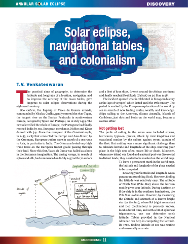
Knowing your latitude and longitude was a paramount stumbling block. However, finding the latitude was relatively easy. The altitude of North Star (Pole Star) above the horizon readily gives your latitude. During daytime, or if the ship is in the southern hemisphere, the Pole Star is of no use. However, by measuring the altitude and azimuth of a known bright star (or the Sun), whose RA (right ascension) and Dec (declination) is precisely known, local sidereal time, and with a bit of spherical trigonometry, one can determine one’s latitude. Tables provided in the Nautical Almanac can help in computing the latitude. By 1700, finding latitude at sea was routine and reasonably accurate.
Solar eclipse,
Solar eclipse,
navigational tables,
navigational tables,
and colonialism
and colonialism
he practical aims of geography, to determine the latitude and longitude of a location, navigation, and to improve the accuracy of the moon tables, gave impetus to solar eclipse observations during the
eighteenth century.
São Gabrie, the flagship of Vasco da Gama's armada,
commanded by Nicolau Coelho, gently entered the river Tagus, the longest river on the Iberian Peninsula in southwestern Europe, occupied by Spain and Portugal, on 12 July 1499. The news electrified the whole of Europe; the Portuguese had finally reached India by sea. European merchants, Nobles and Kings danced with joy. Since the conquest of the Constantinople, in 1453, a city that connected the Europe and Asia-Minor, by the Ottomans, European traders were in search of a sea route to Asia, in particular to India. The Ottomans levied very high trade taxes on the European transit goods passing through their land. Since this feat, Vasco da Gama was hailed as a hero in the European imagination. The daring voyage, in search of spices and silk, had commenced on 8 July 1497 with 170 sailors
june2020/dream2047 11
