
Page 12 - Dream 2047 June 2020
P. 12
ANNULAR S LAR ECLIPSE DISCOVERY
The longitude problem
Computing the longitude however was more difficult. The sailors often had to resort to dead reckoning, a process in which the current position was determined using a previously known location of the ship, say when it was in the port of call and using the estimated speeds over elapsed time and course to guess its current position on a navigational chart. This method was subject to cumulative errors, and often the sailors reached a totally different place than intended. Meandering in the seas, the ships took longer than the necessary time to reach their destinations. With the sea voyages extending beyond the initial estimates, the food stocks ran low, the crew were fed with short rations, leading to various deficiency diseases like scurvy.
Navigation relying on dead reckoning at times wrecked the fleet and left the sailors dead. A famous case is the squadron of British Royal Navy ships that were returning
from Gibraltar in October 1707. The weather
was overcast and stormy. The navigators of the
fleet estimated that they were sailing near the
island of Ushant off Brittany in France, while
actually, they were near the Isles of Scilly, off
the coast of Cornwall, UK. Later that night four
ships rammed into the rocks near the Scilly
Islands and thousands of sailors lost their lives
at sea. It was one of the worst maritime disasters
in British history of that time. The public furore
forced the British government to enact the
Longitude Act of 1714. Rewards were instituted
for anyone coming up with a viable solution to
the problem of finding longitude at sea.
Greenwich Time
If the British announced the Longitude Prize
"for such person or persons as shall discover
the Longitude" and demonstration of a practical
method for determining the longitude of a ship
at sea, other seafaring European nations did not lag behind. Académie Royale des Sciences of France offered two Prix Rouillés specifically for navigation from 1715 onward. Spain and Holland also joined the fray. Navigators and scientists proposed various methods.
It is easy to see that if the time at Greenwich (which was used as the standard reference point) was, say noon, a place 15 degrees longitude west of Greenwich will have a local time of 11 am. A position 15 degrees east of Greenwich will have a local time of 1 pm. In short, the relation between local time and Greenwich Time will be 15 degrees longitude for an hour of difference. If the captain could determine the local time and can compare it with Greenwich Time, the longitude of the location of the ship could be easily computed. Each hour of difference between the Greenwich time and the local time imply 15 degrees of longitude. Finding local time is not a complication. The sundial or a star at the horizon would provide the local time. Thus, the question of finding the longitude reduces to finding the time at Greenwich.
This can be done in two ways. One, you can carry a seaworthy clock that is set to Greenwich Time. The marine chronometer invented by John Harrison relied on this method. Second, you
can use the method of lunar distances to determine Greenwich Time advocated by British Astronomer Royal Nevil Maskelyne based on the process first proposed by Tobias Mayer.
Lunar distance method
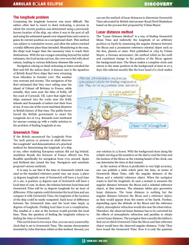
The "Lunar Distance Method" is a way of finding Greenwich Mean Time and indirectly the longitude of an arbitrary position on Earth by measuring the angular distance between the Moon and a prominent reference celestial object such as the Sun, planets or stars. First published in 1763 by Tobias Mayer, a German astronomer, the method relied on the swift and consistent change in the position of the Moon against the background stars. The Moon makes a complete circle and return to the same position in the background of stars in 27.3 days (the sidereal month) like the hour hand of a clock makes
one rotation in 12 hours. With the background stars along the ecliptic serving as the numbers on the dial to read the time and the motion of the Moon as the rotating hands of the clock, one can determine the time at that instant.
As the motion of Moon is predicable to very high accuracy, one can publish a table which pairs the time, in terms of Greenwich Mean Time, with the angular distance of the Moon and a celestial reference object. When the navigator wants to find the longitude, he uses a sextant to measure the angular distance between the Moon and a celestial reference object, at that instance. The almanac tables give geocentric lunar distances. The lunar distance is nothing but the angular distance between the Moon and a reference object, as they would appear from the centre of the Earth. Further, depending upon the altitude of the Moon and the reference object, atmospheric refraction would also mar the observation. Therefore, the observed lunar distance has to be corrected for the effects of atmospheric refraction and parallax to obtain correct lunar distance. The navigator then consults the tables to find out at which Greenwich Time the Moon and that reference object would have the observed angular distance. Voila! They have found the Greenwich Time. Now it is only the question
12 dream2047/june2020
