
Page 13 - Curiosity_Oct_2020
P. 13
of systems. Satellite data-derived geological and hydro-geomorphologic features assist in prospecting the ground water resource to plan aquifer recharging, water harvesting and drinking water sources. High resolution satellite data remarkably augmented the remote sensing services extending it to infrastructure planning and management.
APPLICATIONS
are amenable to detect and map the spatial extent of both forms of water. Accurate information on surface water, its existence, spatial extent, temporal changes is essential to manage this resource judiciously.
watershed, a natural hydrologic unit is considered to be the most appropriate basis. Watershed characterization involves measurement of related parameters, such as geological, hydrogeological, geomorphological,
• Field /Plot boundaries
• Irrigation network/infrastructure
• Cartographic information
• Micro-scale features
• Land use/Land Cover
• Surface Water Resources
• Water logging
• Evapotranspiration
• Soil Moisture
• Surface roughness
• Soil Moisture
• Flood Inundation
• River bank erosion
• River control works
• Surface water
• Snow cover
• Glaciers
• Snow depth
• Snow water equivalent
• Water quality
• Precipitation
The overall applications of geospatial technology in water resources sector can be broadly categorized into the following groups:
I. Water Resources Assessment
II. Water Resources Management
III. Water Resources Development
IV. Watershed Management
V. Flood Disaster Support
VI. Environmental Impact Assessment & Management
VII. Water Resources Information & Decision Support Systems
FEW THEMATIC APPLICATIONS
WATER RESOURCES ASSESSMENT
Surface water occurs in the form of liquid water in lakes, reservoirs, rivers, and in its solid form as snow, glacier and lake ice. Remote sensing platforms
WATERSHED MANAGEMENT
For sustainable integrated management of the land and water resources,
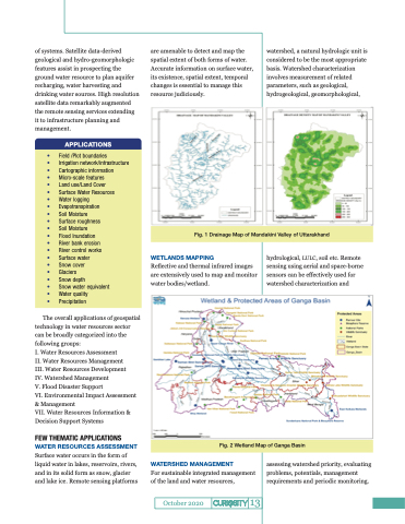
WETLANDS MAPPING
Reflective and thermal infrared images are extensively used to map and monitor water bodies/wetland.
hydrological, LULC, soil etc. Remote sensing using aerial and space-borne sensors can be effectively used for watershed characterization and
assessing watershed priority, evaluating problems, potentials, management requirements and periodic monitoring.
October 2020
Fig. 1 Drainage Map of Mandakini Valley of Uttarakhand
Fig. 2 Wetland Map of Ganga Basin
13
