
Page 57 - ALG Issue 3 2020
P. 57
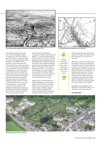
   The Johannes Kip imagined aerial view of Cirencester, dated C1712
The 1884 OS map overlaid with our current map
stone walls and watercourses and
were therefore vulnerable to attack.
On January 7th, 1643, Prince Rupert, nephew to Charles 1, appeared outside the town with a large army, demanding surrender. It was refused and he departed to return with about 6,000 troops and attacked on February 2nd at noon. The attack was two-pronged with forces entering the town from the North via Spitalgate and, of more interest to us, from the North West, led by Price Rupert. Barton House, located close to the allotments, stood in their way and was heavily defended by musketeers. Only after it was set on fire were the defenders forced to retreat. The battle for Cirencester was over in four hours but was very fierce. The allotments could well have formed part of the battleground, although no evidence of this has ever been found. The Royalists held Cirencester until 1645 when the civil war was coming to a close.
In a bird’s-eye view engraving of Cirencester, drawn by Johannes Kip and dated c1712, and a later edition dated 1768, the road to Gloucester is depicted. Although the detail and scale cannot be wholly relied upon, hedge lined fields to the south of the road, behind dwellings, can be clearly seen disappearing North West out of the picture. Their position, roughly where Barton Lane Allotments is now situated, once again suggests that cultivation of this piece of land
was being carried out in the eighteenth century and has, almost certainly, continued without let up to today.
Many artefacts of interest have been found by plotholders over the years in addition to the Roman coin, including shards of pottery considered to be of Roman origin, old bottles, clay pipe stems and bowls, jewellery, silver cutlery, many blacksmith-made items and most recently, a George III silver
Many artefacts of interest have been found by plotholders over the years
shilling (a male labourer’s daily wage) dated 1818. Imagine toiling on your plot, then going home to find you’d lost a day’s pay!
We have the record of a ‘numerous and respectable’ meeting from 1833 held in Cirencester town hall, where adoption of a system of ‘allotting portions of land’ to ‘permanently to raise the character and better the condition of the labourer’ was enthusiastically discussed. The 1884 Ordnance Survey map of Cirencester clearly shows St Lawrence Gardens, now Barton Lane Allotments, and the layout is remarkably similar to today. Were the allotments originally founded as a result of that earlier meeting?
Cirencester town and Barton Lane Allotments, both steeped in history, are well worth a visit. All are welcome.
Ken Wallington
          Contemporary aerial view of the site
Allotment and Leisure Gardener 57
