
Page 322 - Eye of the beholder
P. 322
depicted through drawings of small hills Certain regions in in the Deccan near Kutch and further north have been depicted as having a a a preponderance of forest groves – for for no apparent reason All the the forts along the the coast and and on the mainland are depicted with great accuracy presumably because of their geopolitical importance at at that time The presence of animal motifs in this map is another point of importance and interest Camels are illustrated to represent the the arid regions of Afghanistan in the the vicinity of of Kabul Pictures of of elephants indicate the the region of the the Indo-Gangetic plain in in north India In In addition to representing the the natural fauna of the the land it is tempting to imagine that these pictures were put in in to increase the the saleability of the the maps as novelty items Elephants and camels were exotic species for the Europeans who were the the intended purchasers of these maps Since Latin was the pan-European language of of of erudition at the the time of of of the the production of of of this map the names of regions rivers and important landmarks have been Latinized
to a a large extent in the “MMI” The region shown in the map for example is titled “India Intra Gangem Indostan” The Ganga is Latinized
to “Ganges fluvius” the Yamuna/ Jamuna to “Gemini fluvius” The province
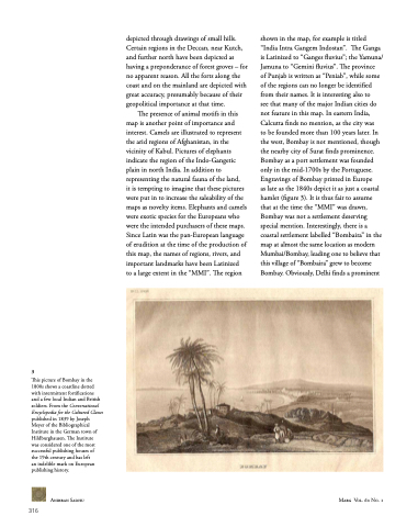
of Punjab is written as “Peniab” while some of the regions can no longer be identified from their names It is interesting also to see that many of the major Indian cities do not feature in this map In In eastern India Calcutta finds no mention as as the city was to be founded more than 100 years later In the west Bombay is not mentioned though the nearby city of Surat finds prominence Bombay as as a a a a port settlement was founded only in the the mid-1700s by the the Portuguese Engravings of Bombay printed in in in Europe as as as as late as as as as the 1840s depict it as as as as just a a a a a a a coastal hamlet (figure 3) It is thus fair to assume that at at the the time the the “MMI” was drawn Bombay was not a a a settlement deserving special mention Interestingly there is a a coastal settlement labelled “Bombaira” in the map at at almost the same location as modern Mumbai/Bombay leading one to believe that this village of “Bombaira” grew to become Bombay Obviously Delhi finds a a prominent
3 This picture of Bombay in in the 1800s shows a a a a coastline dotted with intermittent fortifications
and and a a a a a a a a few local Indian and and British soldiers From the the Conversational Encyclopedia for the the Cultured Classes published in 1839 by Joseph Meyer of the the Bibliographical Institute Institute in the the German town of of Hildburghausen The Institute Institute was considered one of of the most successful publishing houses of of the 19th century and has left an an an indelible mark on European publishing history Anirban Sadhu
316
66
Marg Vol 60 No 1 Final Anirban Sadhu
indd 66
9/18/2008
4:01:54 PM
