
Page 241 - US History
P. 241
Chapter 8 | Growing Pains: The New Republic, 1790–1820 231
most profitable sugar island in the world, had failed. The emperor therefore agreed to the sale in early 1803.
Click and Explore
Explore the collected maps and documents relating to the Louisiana Purchase and its history at the Library of Congress (http://openstaxcollege.org/l/LaPurchase) site.
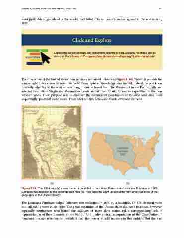
The true extent of the United States’ new territory remained unknown (Figure 8.14). Would it provide the long-sought quick access to Asian markets? Geographical knowledge was limited; indeed, no one knew precisely what lay to the west or how long it took to travel from the Mississippi to the Pacific. Jefferson selected two fellow Virginians, Meriwether Lewis and William Clark, to lead an expedition to the new western lands. Their purpose was to discover the commercial possibilities of the new land and, most importantly, potential trade routes. From 1804 to 1806, Lewis and Clark traversed the West.
Figure 8.14 This 1804 map (a) shows the territory added to the United States in the Louisiana Purchase of 1803. Compare this depiction to the contemporary map (b). How does the 1804 version differ from what you know of the geography of the United States?
The Louisiana Purchase helped Jefferson win reelection in 1804 by a landslide. Of 176 electoral votes cast, all but 14 were in his favor. The great expansion of the United States did have its critics, however, especially northerners who feared the addition of more slave states and a corresponding lack of representation of their interests in the North. And under a strict interpretation of the Constitution, it remained unclear whether the president had the power to add territory in this fashion. But the vast
