
Page 112 - Walks In The Black Range
P. 112
24. Pipeline Bridge Trail
As you travel east from Hillsboro you climb a significant grade and then enter a series of curves. The third gated road on the south provides access to the southern reaches of Ready Pay Gulch.
There are a number of walks which are possible in the Ready Pay Gulch area. After you go through the gate the road to the fork in the road (starting point of walk) is rutted and rocky, travel by low clearance cars is not recommended. The usual suspects are on-the-scene; rattlesnakes (only Western Diamond-Back that I know of), Black Bear, Coyote, and Cougar are all possible - but not likely.
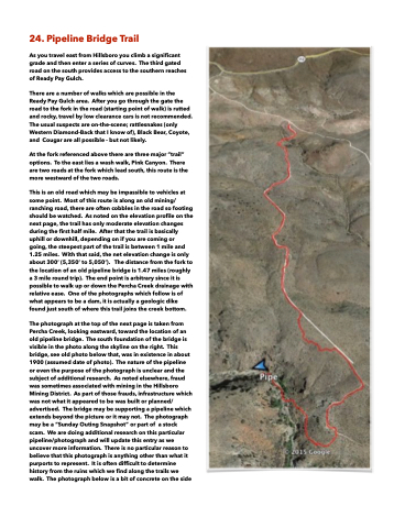
At the fork referenced above there are three major “trail” options. To the east lies a wash walk, Pink Canyon. There are two roads at the fork which lead south, this route is the more westward of the two roads.
This is an old road which may be impassible to vehicles at some point. Most of this route is along an old mining/ ranching road, there are often cobbles in the road so footing should be watched. As noted on the elevation profile on the next page, the trail has only moderate elevation changes during the first half mile. After that the trail is basically uphill or downhill, depending on if you are coming or going, the steepest part of the trail is between 1 mile and 1.25 miles. With that said, the net elevation change is only about 300‘ (5,350’ to 5,050’). The distance from the fork to the location of an old pipeline bridge is 1.47 miles (roughly a 3 mile round trip). The end point is arbitrary since it is possible to walk up or down the Percha Creek drainage with relative ease. One of the photographs which follow is of what appears to be a dam, it is actually a geologic dike found just south of where this trail joins the creek bottom.
The photograph at the top of the next page is taken from Percha Creek, looking eastward, toward the location of an old pipeline bridge. The south foundation of the bridge is visible in the photo along the skyline on the right. This bridge, see old photo below that, was in existence in about 1900 (assumed date of photo). The nature of the pipeline or even the purpose of the photograph is unclear and the subject of additional research. As noted elsewhere, fraud was sometimes associated with mining in the Hillsboro Mining District. As part of those frauds, infrastructure which was not what it appeared to be was built or planned/ advertised. The bridge may be supporting a pipeline which extends beyond the picture or it may not. The photograph may be a “Sunday Outing Snapshot” or part of a stock scam. We are doing additional research on this particular pipeline/photograph and will update this entry as we uncover more information. There is no particular reason to believe that this photograph is anything other than what it purports to represent. It is often difficult to determine history from the ruins which we find along the trails we walk. The photograph below is a bit of concrete on the side
