
Page 44 - Walks In The Black Range
P. 44
10. South Percha - Drummond Canyon
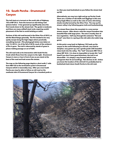
The trail starts at a turnout on the south side of Highway 152 at MP 35.6. From the turnout an old mining road (picture below - it has greened up significantly since the fire) travels down to the stream bed. The grade is moderate and there are many softball sized rocks requiring careful placement of the feet to avoid twisting an ankle.
Portions of this old road burned in the Silver Fire of 2013, as did the Black Range generally. The fire tended to be very spotty except along the high ridges where practically everything burned. (The photograph below was taken on July 13, 2013.) As of the fall of 2018, much of the evidence of fire is gone. The trail is obscured by stands of grass in places making passage an act of faith.
The old road ends at its intersection with South Percha Creek which flows from the canyon to the right. Drummond Canyon is more or less in front of you as you stand at the base of the road and look across the stream.
The map on the following page depicts a short walk (1 mile from NM-152 to the termination point in Drummond Canyon) which is reasonably easy. After you cross South Percha you may be able to follow an old road on the southeast side of Drummond Canyon for a hundred yards or
so, then you must bushwhack as you follow the stream bed up hill.
Alternatively, you may turn right and go up Percha Creek. There are a number of old shafts and diggings in this area (Gray Eagle Mine) as well as the ruins of some old mining shacks (mostly burned by the Silver Fire). The way up the stream valley is by following game trails and bushwhacking.
The stream flows down the mountain in a very narrow stream canyon. After about a mile the canyon broadens into beautiful flats with large pines. The area is mostly clear of low vegetation. Half way through this extensive “flat and broad” area there is a spring at the old cabin site (cabin long gone).
At this point a way back to Highway 152 leads up the canyon to the north following an old trail, very hard to decipher, very grown-up, but a gentle grade with beautiful views back into the valley. The “trail” intersects NM-152 at about MP 34.8. It is close to impossible to locate this “trail” head if you don’t have good directions, the trail is not discernible - it is simply a way forward which is less overgrown than its surroundings. Not obvious at all. Unless you know the location of the old trail it is probably best to bushwhack back down South Percha to the old road.
