
Page 66 - Walks In The Black Range
P. 66
As you walk up North Wicks Canyon, from NM-152, you will see an old house (photographs on next two pages) along the wash to the east of the main mining road. (The house photographs date from March 22, 2014.) There are many alternative walking areas, variations of the walk to Black Peak described above, in North Wicks Canyon.
Lower Peak
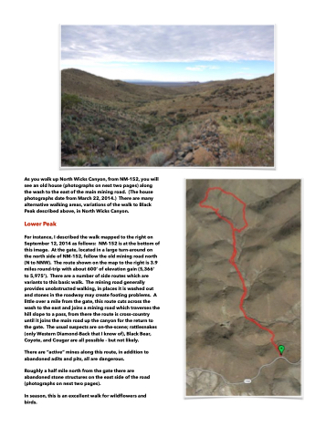
For instance, I described the walk mapped to the right on September 12, 2014 as follows: NM-152 is at the bottom of this image. At the gate, located in a large turn-around on the north side of NM-152, follow the old mining road north (N to NNW). The route shown on the map to the right is 3.9 miles round-trip with about 600’ of elevation gain (5,366’ to 5,975’). There are a number of side routes which are variants to this basic walk. The mining road generally provides unobstructed walking, in places it is washed out and stones in the roadway may create footing problems. A little over a mile from the gate, this route cuts across the wash to the east and joins a mining road which traverses the hill slope to a pass, from there the route is cross-country until it joins the main road up the canyon for the return to the gate. The usual suspects are on-the-scene; rattlesnakes (only Western Diamond-Back that I know of), Black Bear, Coyote, and Cougar are all possible - but not likely.
There are “active” mines along this route, in addition to abandoned adits and pits, all are dangerous.
Roughly a half mile north from the gate there are abandoned stone structures on the east side of the road (photographs on next two pages).
In season, this is an excellent walk for wildflowers and birds.
