
Page 6 - Volume 3 - Walks In The Black Range
P. 6
1. Continental Divide Trail at Kline Mountain
On February 3, 2018 we hiked a short section of the Continental Divide Trail in the northern part of the Black Range. The trail head is on the south side of NM-59, west of Poverty Flat. Kline Mountain is the prominent feature along the trail at this point. Our walk on this day was time-limited, it is more than two hours from our home in Hillsboro to the trail head. In former times we might not have considered that significant but now, when we can take a five minute drive from our home and walk all day without seeing anyone, we do. Even though it was a drive, we took our time, enjoying the lovely scenery along NM-52 and NM-59 - after a leisurely breakfast at Carmen’s in Truth or Consequences.
We have walked this section of trail several times in the past and because of that were able to assess how this area is recovering from the fires of the recent past - and it is recovering very well. In the past we have seen Elk, Abert’s Squirrel, and Grace’s Warbler along this section. Today there was little of that (although the Bluebirds, both Mountain and Western, were in their usual flocks along NM-52 and NM-59). There were a few small patches of snow along parts of the trail. The trail is obvious, with large cairns and Continental Divide markers for those who might stray. The trail base is mostly needle duff at the northern end, quickly changing to rocks, back and forth between the two as you walk along.
This walk is “out and back", we started the track recording at the southern end of our walk. Therefore, the elevation profile for the trail starts at the southern end of the trail (left side of profile) and proceeds to the trailhead (right side of the profile) - why is it “backward” - operator error.
This walk was 6.8 miles long (3.4 each way), with a climb from 7,669’ to 8,347’ as you head south. The gross elevation gain is something over 600 feet in the course of
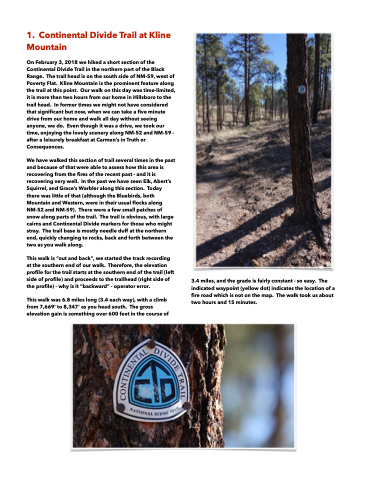
3.4 miles, and the grade is fairly constant - so easy. The indicated waypoint (yellow dot) indicates the location of a fire road which is not on the map. The walk took us about two hours and 15 minutes.
