
Page 81 - Volume 3 - Walks In The Black Range
P. 81
23. North Percha Creek (FT 757)
Contributed by Devon Fletcher
The trail up North Percha is not on the Aldo Leopold Wilderness map, nor the Gila National Forest map. It is on the USGS topographic map and the Forest Service topographic maps of the area, but for the most part it is still a forgotten trail in a remote area of the forest known and used mainly by hunters and locals. Still it’s a great day-hike if you happen to be visiting Hillsboro or Kingston, or if you’re already familiar with the more “popular” Black Range trails and want to try something different. Access to the trailhead is off of NM 152 about 6 miles west of Hillsboro. Be on the lookout for a small brown Forest Trail sign. (Note: this road is signed now and is called the North Percha Road and there is a much larger brown sign listing various destinations along the road). This is where you will turn off. If approaching from Kingston it is perhaps 2 -3 miles east of the town. There may be an even more smaller sign with 157 on it, also indicating your turnoff to the north. You will drive approximately 8-9 miles on this mostly good gravel road. You will go through a posted private inholding. Do not cross North Percha Creek but drive straight on past the private property.
This hike is a Black Range classic, but be forewarned, there is very little room to park or maneuver past the private property. If you don’t have high clearance and four wheel drive, park as soon as you can once you are beyond the
private property. Even if your vehicle is properly equipped, you will probably only be able to manage the first crossing beyond which there is a good camping and a parking area. It is inadvisable to venture any farther in any sort of vehicle.
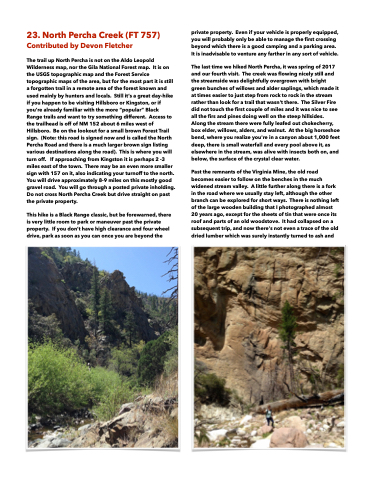
The last time we hiked North Percha, it was spring of 2017 and our fourth visit. The creek was flowing nicely still and the streamside was delightfully overgrown with bright green bunches of willows and alder saplings, which made it at times easier to just step from rock to rock in the stream rather than look for a trail that wasn't there. The Silver Fire did not touch the first couple of miles and it was nice to see all the firs and pines doing well on the steep hillsides. Along the stream there were fully leafed out chokecherry, box elder, willows, alders, and walnut. At the big horseshoe bend, where you realize you're in a canyon about 1,000 feet deep, there is small waterfall and every pool above it, as elsewhere in the stream, was alive with insects both on, and below, the surface of the crystal clear water.
Past the remnants of the Virginia Mine, the old road becomes easier to follow on the benches in the much widened stream valley. A little further along there is a fork in the road where we usually stay left, although the other branch can be explored for short ways. There is nothing left of the large wooden building that I photographed almost 20 years ago, except for the sheets of tin that were once its roof and parts of an old woodstove. It had collapsed on a subsequent trip, and now there's not even a trace of the old dried lumber which was surely instantly turned to ash and
