
Page 88 - Volume 3 - Walks In The Black Range
P. 88
Giant alligator junipers began showing up as the valley widened. So did the first spot that could have been used for camping, where we saw a long, long abandoned fire ring. When it looked like the canyon would narrow again before reaching our tentative goal of the forest service boundary, we called it a half a day, rested a bit and began our return. We decided against trying to find a cattle path up above, as none of the ones we had seen coming down to the canyon seemed particularly well trod, and who knows what direction they would ultimately lead. Bushwhacking with a pleasant stream where our dogs could drink and wade to stay cool, and we could listen to the little falls, beats bushwhacking on the slopes of the dry hills any day.
Close to creek we found the ruins (really just one corner of timbers and a pile of stones that was the fireplace) of another cabin with abundant metal trash all around. This one would be real easy to walk by without even seeing unless you happened to kick one of the rusty cans.
NOTES: 1. One of the nice things I noticed while hiking this canyon bottom is that it's too narrow and rough for cattle to pass through it. 2. The mile of FR 157 after crossing North Percha to get to our starting point, had seen some improvements after the Silver Fire, but now without maintenance it's just as bad as ever (although mercifully wider). 3. The canyon is named for a 19th century prospector and ranch hand Albert Dumm who had a cabin on the creek (perhaps one of the ones we saw). 4. From the parking area a road follows the upper portion of Dumm Canyon to the west for a half mile or so. This could be a pleasant cool weather walk as well, but don’t expect any water in stream except very early in the spring. (Ed.: See Bald Hill Spring Walk - spring indicated by arrow on map on previous page.)
26. Cave Creek to East Curtis Canyon or Las Animas Creek (FT
307 & 117)
Contributed by Devon Fletcher
I’ve hiked the southern portion of FT 307 three times. First, a few words about the trailhead and getting to the trailhead. You may see on some maps the trail starting down on Cave Creek from the furthest extension FR 157. This is more or less correct. Some maps show the road continuing north from there and the trail starting at some point before reaching the ridge and the intersection with FT 117. This is no longer correct. The road, may have existed in some form to that point at one time, traces of double track can be seen in places, but it is not at all practical to even attempt to cross Cave Creek in any sort of vehicle now. All that being said, it is highly unlikely you will want to drive all the way to the trailhead anyway. Unless you have high clearance, four wheel drive and experience with roads in extremely poor condition you should stop somewhere
before the 1⁄2 mile descent to Cave Creek. To be clear, the preceding two and a quarter miles from North Percha are no prize either. It’s all a matter of how much appetite you have for this kind of driving. The trail was signed the last time I was there in 2016, but just in case, know that it is only about two tenths of mile from where the road turns sharply to the east as it reaches Cave Creek. There is a large cairn that marks where Trail 307 turns to the north.
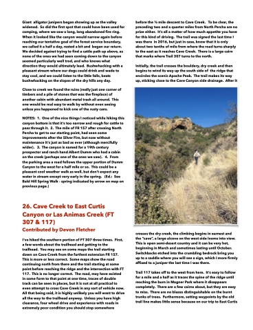
Initially, the trail crosses the bouldery, dry creek and then begins to wind its way up the south side of the ridge that encircles the scenic Apache Peak. The trail makes its way up, sticking close to the Cave Canyon side drainage. After it
crosses the dry creek, the climbing begins in earnest and the “cave”, a large alcove on the west side looms into view. This is open semi-desert country and it can be very hot, beginning in March and sometimes lasting until October. Switchbacks etched into the crumbling bedrock bring you up to a saddle where you will see a sign, which I more firmly affixed to a juniper the last time I was there.
Trail 117 takes off to the west from here. It’s easy to follow for a mile and a half as it traces the spine of the ridge until reaching the burn in Magner Park where it disappears completely. There are a few cairns about, but they are easy to miss. There are no blazes distinguishable on the burnt trunks of trees. Furthermore, setting waypoints by the old trail line makes little sense because on our trip to East Curtis
