
Page 13 - Black Range Naturalist, Vol. 1, No. 2
P. 13
night. An estimate of the flow 3.5 miles southwest of Hillsboro in the Trujillo drainage indicated that it might have been in the range of 20,000 cubic feet per second.
(See “B” annotation.) At the same time that water was raging down the Trujillo, a six-foot wall of water roared through Hillsboro resulting in one death (Murphy) and significant damage. (See “A” annotation for relative location of Hillsboro compared to the Trujillo watershed.) This storm dumped a lot of water over a very wide area in a relatively short period of time.
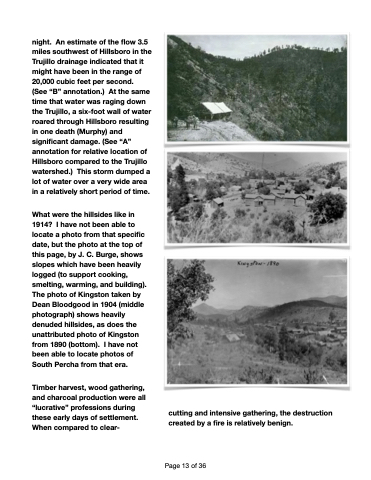
What were the hillsides like in 1914? I have not been able to locate a photo from that specific date, but the photo at the top of this page, by J. C. Burge, shows slopes which have been heavily logged (to support cooking, smelting, warming, and building). The photo of Kingston taken by Dean Bloodgood in 1904 (middle photograph) shows heavily denuded hillsides, as does the unattributed photo of Kingston from 1890 (bottom). I have not been able to locate photos of South Percha from that era.
Timber harvest, wood gathering, and charcoal production were all “lucrative” professions during these early days of settlement. When compared to clear-
cutting and intensive gathering, the destruction created by a fire is relatively benign.
Page 13 of 36
