
Page 18 - Black Range Naturalist, Vol. 2, No. 2
P. 18
raveolens), scarlet gilia (Ipomopsis aggregata), sweet four o’clock (Mirabilis longiflora), mountain leaftail (Pericome caudata), and Carruth sagewort (Artemisia carruthii). Mimbres figwort is a USFWS and State of New Mexico Species of Concern and is a Forest Service Sensitive species. NatureServe gives Mimbres figwort an updated conservation rank of S2 (imperiled) (2016).
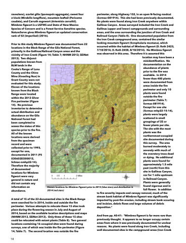
Prior to this study Mimbres figwort was documented from 22 locations in the Black Range of the Gila National Forest, primarily in the Gallinas/Railroad Canyon areas and the vicinity of Iron Creek (Figure 14; Table 7; NHNM 2013; SEINet 2013). Two disjunct
perimeter, along Highway 152, in an open N-facing roadcut (Scrmac-081914). This site had been previously documented. No plants were found along Iron Creek anywhere within Gallinas Canyon. Areas surveyed included the Iron Creek and Gallinas (upper and lower) campgrounds and surrounding areas, and the area surrounding the junction of Iron Creek and Railroad Canyon (Table 8). One documented population from the Iron Creek campground area, contained the similar looking mountain figwort (Scrophularia montana), which occurred within the habitat of Mimbres figwort (D. Roth 2423, 7/18/2014; D. Roth 2458, 8/18/2014). No Mimbres figwort was observed in this area. Therefore it is assumed this
populations known from BLM lands in the Cooke’s Range of Luna County and the Chino Mine (Kneeling Nun) in Grant County were not evaluated for this study. Eleven of the locations known from the Black Range were located within the 2013 Silver Fire perimeter (Figure 14). No previous inventories to determine actual distribution and abundance on the Gila National Forest had been completed to assess the status of this species prior to the fire. All of the known locations were derived from the specimen record and were collected prior to 1993, except for one, documented in 2011 (FS 030602EO00012, Sclmac-nmhp22-14). Therefore the majority of documented locations for Mimbres figwort were very general in nature and did not contain any information on abundance.
Known locations for Mimbres Figwort prior to 2013 (blue stars) and distribution in
location may have been a misidentification. No documentation on the abundance of plants prior to the fire was available. In 2014 fewer than 400 plants were documented from areas inside the fire perimeter and only 10 plants were found outside the fire perimeter (Table 7; Scrmac-081914).
Except for one site (Scrmac-mhp22-15-14), plants were largely scattered in small groupings of 25 or fewer plants per site. The site with the most plants was the northernmost occupied site documented during this survey. The area burned moderately to severely with much of the overstory trees dead or dying. No additional plants were found for approximately 1.5 mile past (north) from this site in Gallinas Canyon, nor for 1 mile upstream in Railroad Canyon. Plants were generally found vigorous and in full flower. In addition
2014 (red stars)
to fire severity impacts and canopy removal, much of the stream bank habitat of Mimbres figwort was significantly impacted by post-fire erosion, including stream bank scouring and incision, debris flows and large volumes of debris deposition.”
And from pp. 40-41: “Mimbres figwort is far more rare than previously thought. It appears to no longer occupy certain areas from where it was previously documented for unclear reasons. No plants were found along Iron Creek, including well documented sites in the campground areas (Iron Creek
A total of 15 of the 22 documented sites in the Black Range were searched for in 2014, inside and outside the fire perimeter. Various attempts to relocate these 15 sites took place during the flowering season in July and August of 2014, based on the available location descriptions and maps (NHNM 2013, SEINet 2013). Only three of these 15 sites could be relocated with extant plants (Table 8). Two general locations containing 16 occupied sites were found during surveys, one of which was inside the fire perimeter (Figure 14, Table 7). The second location was outside the fire
18
