
Page 40 - Walks In The Black Range, Vol. 4
P. 40
7. Forest Trail 134
This route starts at Tierra Blanca Road and terminates at the Black Range Crest Trail north of Sawyer’s Peak. Trail conditions in the Black Range, since the Silver Fire, are problematic. Although the walk described here is fairly straight forward and at least as good as a good cow path, for the four miles round-trip shown here, it is not certain what the upper portions of the trail may be like. In 2021 there was a 500+ acre spot fire in the area. The junction with the Crest Trail is not apparent at the upper end.
The trail head is about 14 miles from NM-27 on a dirt road which gets progressively worse as you proceed. A high clearance vehicle is recommended. The bottom map to the right shows the detail of the upper map, after you cross into the National Forest. The star on the lower map indicates the trailhead for Forest Trail 135.
All of the photographs in this trail description were taken on April 25, 2020.
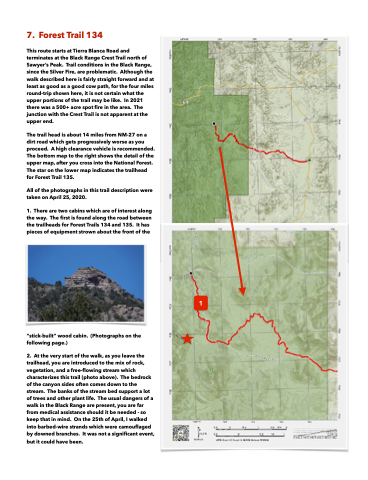
1. There are two cabins which are of interest along the way. The first is found along the road between the trailheads for Forest Trails 134 and 135. It has pieces of equipment strown about the front of the
“stick-built” wood cabin. (Photographs on the following page.)
2. At the very start of the walk, as you leave the trailhead, you are introduced to the mix of rock, vegetation, and a free-flowing stream which characterizes this trail (photo above). The bedrock of the canyon sides often comes down to the stream. The banks of the stream bed support a lot of trees and other plant life. The usual dangers of a walk in the Black Range are present, you are far from medical assistance should it be needed - so keep that in mind. On the 25th of April, I walked into barbed-wire strands which were camouflaged by downed branches. It was not a significant event,
but it could have been.
1
