
Page 5 - Walks In The Black Range, Vol. 4
P. 5
10. Ciénega Trail - City of Rocks State Park
The trailhead for this walk is just north of NM 61 on the City of Rocks State Park road. This is rare habitat for the Black Range.
11. Cooke’s Townsite
From the townsite west (and up) to the saddle north of Cooke’s Peak.
12. Cooke’s Peak
Cooke’s Peak is the land mark of the southern Black Range. This walk is an easy way to study the history of Cooke’s Townsite and the adjacent mining ruins.
13. Massacre Peak/Cooke’s Spring Pass
This route follows the old Butterfield Stage Coach Route (known by many earlier names) from Cooke’s Spring at Fort Cummings to Frying Pan Canyon.
14. Frying Pan Spring
The walk from the Starvation Creek Detention Dam No. 4 site to Frying Pan Spring is about 4 miles roundtrip. It starts along the track which was the Butterfield stage route and then turns north (at the approximate location of Cooke’s camp) up Frying Pan Canyon.
15. Sadler Mine
Mine site at the south end of Pony Hills, to the west of Green Leaf Mine.
16. China Draw
To the west of Pony Hills near an RV camping site. This is a short walk to a petroglyph site located on State Trust Land.
17. McGee Canyon
This petroglyph site is northwest of the Pony Hills site. The “trailhead” is roughly in the vicinity of that used for the Pony Hills petroglyph site. From there hike east across Starvation Draw to a retention dam.
Generally speaking, the trails in this volume are grouped along the NM 152 corridor in the north and the area dominated by Cooke’s Peak in the south. The significant area in between the two is not covered in this edition.
1. Lower Gallinas Canyon
The trail starts at a turnout on the south side of Highway 152 about 1.5 miles west of the Lower Gallinas Campground. Across NM 152 (on the north side) is the road which leads down to the Noonday Canyon and Rabb Park walks described in Volume 3. The walk described here has two distinct sections. From the trailhead the walk heads south and downhill, passing a spring before reaching the stream. The second half of the walk is along the stream.
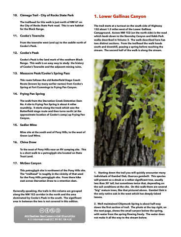
1. Starting down the trail you will quickly encounter many individuals of Gambel Oak, Quercus gambelii. This species will present as a shrub or a rather significant tree, usually less than 30’ tall, but sometimes twice that, depending on the soil conditions at the site. On this walk there are several “big” mature trees, like that pictured above. Gambel Oak is the only native oak in the west which has deeply-lobed leaves.
2. Well maintained Chipmunk Spring is about half-way down the first section of trail. The photo at the top right, on the next page, shows the small canyon below the spring, with water from the spring flowing freely. The water does not make it all the way to the stream below.
